Khajuraho Group of Monuments geodata
Khajuraho Group of Monuments (Madhya Pradesh) is a populated place; located in India in Asia/Kolkata (GMT+5.5) time zone. With population of 25,662 people, there are 1658 cities with bigger population in this country. Compared to other cities in India, 62.7% of cities are located further ↓South; 67.3% of cities are located further ←West and 53% of cities have lower elevation than Khajuraho Group of Monuments. Note1
Current local time in Khajuraho Group of Monuments:
09:43 AM, FridayDifference from your time zone: hours


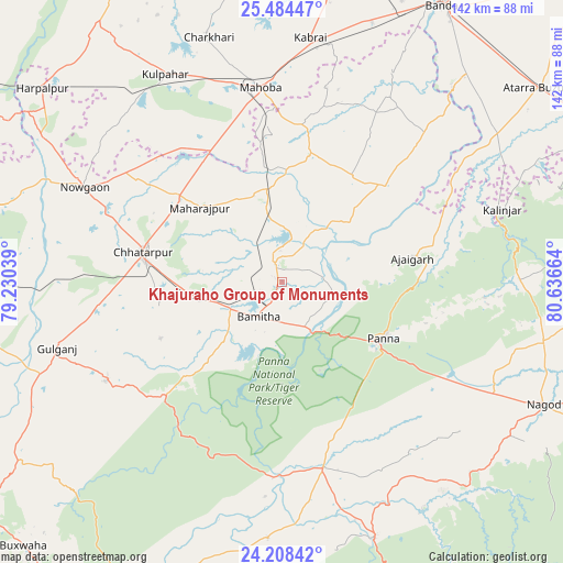
Khajuraho Group of Monuments GPS coordinates[2]
24° 50' 53.124" North, 79° 56' 0.636" East
| Map corner | latitude | longitude |
|---|---|---|
| Upper-left | 25.48447°, | 79.23039° |
| Center: | 24.84809°, | 79.93351° |
| Lower-right: | 24.20842°, | 80.63664° |
| Map W x H: | 141.9×141.9 km | = 88.2×88.2mi |
| max Lat: | 34.9274° ⇑37.3% North |
| Khajuraho Group of Monuments: | 24.84809° |
| min Lat: | ⇓62.7% South 8.09008° |
| min Long | Khajuraho Group | max Long |
| 68.82655° | 79.93351° | 96.81° |
| W 67.3%⇐ | ⇒32.7% E |
Elevation
Elevation of Khajuraho Group of Monuments is 218 m = 715 ft, and this is 77.6 m = 255 ft below average elevation for this country.
| Max E: |
3681 m = 12077 ft | 47% |
| Avg. | 295.6 m = 970 ft | |
| Khajuraho Group of Monuments | 218 m = 715 ft | |
Min E: |
1 m = 3 ft | 53% |
See also: India elevation on elevation.city.
Geographical zone
Khajuraho Group of Monuments is located in North temperate zone (between Tropic of Cancer and the Arctic Circle). Distance of this Northern Tropic circle is 156.9 km =97.5 mi to South.| Distance of | km | miles | from Khajuraho Group of Monuments |
|---|---|---|---|
| North Pole | 7244.2 | 4501.3 | to North |
| Arctic Circle | 4638.3 | 2882.1 | to North |
| Tropic Cancer | 156.9 | 97.5 | to South |
| Equator | 2762.8 | 1716.7 | to South |


Nearby cities:
15 places around Khajuraho Group of Monuments: (largest is in red/bold)
• Ajaigarh
33.3 km =20.7 mi,  80°
80°
• Amānganj
48 km =29.8 mi,  167°
167°
• Bijāwar
51.3 km =31.9 mi,  240°
240°
• Chandla
36.1 km =22.4 mi,  46°
46°
• Charkhāri
64.4 km =40 mi,  343°
343°
• Chhatarpur
35.6 km =22.1 mi,  282°
282°
• Kabrāi
62 km =38.5 mi,  6°
6°
• Kulpahār
60.3 km =37.5 mi,  330°
330°
• Mahobā
49.5 km =30.8 mi,  353°
353°
• Mataundh
69.1 km =42.9 mi,  18°
18°
• Naraini
66.5 km =41.3 mi,  55°
55°
• Nāgod
73 km =45.4 mi,  115°
115°
• Panna
29.3 km =18.2 mi, 118°
• Pawai
68.7 km =42.7 mi,  160°
160°
• Rājnagar
5.1 km =3.2 mi, 334°
In other languages:
- In Spanish: Khajuraho
- In France: Khajurâho
- In German: Khajuraho
- In Russian: Кхаджурахо
Sources, notices
• [Note1] Compared only with cities in India existing in our database
• [Src1] Map data: © OpenStreetMap contributors (CC-BY-SA)
• [Src2] Other city data from geonames.org with taken over terms of usage.
• [Src3] Geographical zone / Annual Mean Temperature by Robert A. Rohde @ Wikipedia
