Qeładizê geodata
Qeładizê (Sulaymaniyah) is a seat of a second-order administrative division; located in Iraq in Asia/Baghdad (GMT+3) time zone. In our database, there are 71 cities with bigger population. Compared to other cities in Iraq, 76.1% of cities are located further ↓South; 69% of cities are located further ←West and 82.4% of cities have lower elevation than Qeładizê. Note1


Qeładizê GPS coordinates[2]
36° 10' 57.144" North, 45° 7' 48.612" East
| Map corner | latitude | longitude |
|---|---|---|
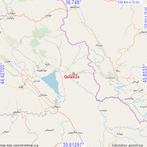
| Upper-left | 36.748°, | 44.42705° |
| Center: | 36.18254°, | 45.13017° |
| Lower-right: | 35.61297°, | 45.8333° |
| Map W x H: | 126.2×126.2 km | = 78.4×78.4mi |
| max Lat: | 37.22781° ⇑23.9% North |
| Qeładizê: | 36.18254° |
| min Lat: | ⇓76.1% South 29.97421° |
| min Long | Qeładizê | max Long |
| 40.28586° | 45.13017° | 48.47309° |
| W 69%⇐ | ⇒31% E |
Elevation
Elevation of Qeładizê is 601 m = 1972 ft, and this is 308 m = 1010 ft above average elevation for this country.
| Max E: |
1316 m = 4318 ft | 17.6% |
| Qeładizê | 601 m 1972 ft | |
| Avg. | 293 m = 961 ft | |
Min E: |
1 m = 3 ft | 82.4% |
See also: Iraq elevation on elevation.city.
Geographical zone
Qeładizê is located in North temperate zone (between Tropic of Cancer and the Arctic Circle). Distance of this Northern Tropic circle is 1417.2 km =880.6 mi to South.| Distance of | km | miles | from Qeładizê |
|---|---|---|---|
| North Pole | 5983.9 | 3718.2 | to North |
| Arctic Circle | 3378.1 | 2099.1 | to North |
| Tropic Cancer | 1417.2 | 880.6 | to South |
| Equator | 4023.1 | 2499.8 | to South |


Nearby cities:
15 places around Qeładizê: (largest is in red/bold)
• As Sulaymānīyah
73.9 km =45.9 mi,  158°
158°
• Choman
54.9 km =34.1 mi,  336°
336°
• Chwarta
64.9 km =40.3 mi,  142°
142°
• Dukan
31.9 km =19.8 mi,  208°
208°
• Halshaw
12 km =7.5 mi,  75°
75°
• Hayraw
15.1 km =9.4 mi,  114°
114°
• Hīrān
58.1 km =36.1 mi,  280°
280°
• Jamjamāl
76.9 km =47.8 mi,  200°
200°
• Koysinceq
46.4 km =28.8 mi,  256°
256°
• Mawet
40.4 km =25.1 mi, 140°
• Nāḩiyat Hīrān
58.6 km =36.4 mi, 280°
• Ruwāndiz
72.3 km =44.9 mi,  311°
311°
• Shaqlāwah
76.2 km =47.3 mi,  288°
288°
• Soran
74.1 km =46 mi, 314°
• Ṟaniye
23.6 km =14.7 mi, 289°
Sources, notices
• [Note1] Compared only with cities in Iraq existing in our database
• [Src1] Map data: © OpenStreetMap contributors (CC-BY-SA)
• [Src2] Other city data from geonames.org with taken over terms of usage.
• [Src3] Geographical zone / Annual Mean Temperature by Robert A. Rohde @ Wikipedia
