Soran geodata
Soran (Arbīl) is a seat of a second-order administrative division; located in Iraq in Asia/Baghdad (GMT+3) time zone. With population of 125,000 people, there are 23 cities with bigger population in this country. Compared to other cities in Iraq, 89.4% of cities are located further ↓South; 54.9% of cities are located further ←West and 85.2% of cities have lower elevation than Soran. Note1


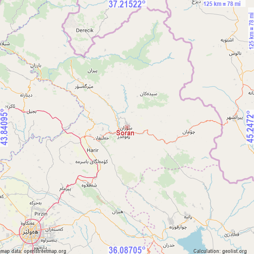
Soran GPS coordinates[2]
36° 39' 11.52" North, 44° 32' 38.652" East
| Map corner | latitude | longitude |
|---|---|---|
| Upper-left | 37.21522°, | 43.84095° |
| Center: | 36.6532°, | 44.54407° |
| Lower-right: | 36.08705°, | 45.2472° |
| Map W x H: | 125.4×125.4 km | = 77.9×77.9mi |
| max Lat: | 37.22781° ⇑10.6% North |
| Soran: | 36.6532° |
| min Lat: | ⇓89.4% South 29.97421° |
| min Long | Soran | max Long |
| 40.28586° | 44.54407° | 48.47309° |
| W 54.9%⇐ | ⇒45.1% E |
Elevation
Elevation of Soran is 679 m = 2228 ft, and this is 386 m = 1266 ft above average elevation for this country.
| Max E: |
1316 m = 4318 ft | 14.8% |
| Soran | 679 m 2228 ft | |
| Avg. | 293 m = 961 ft | |
Min E: |
1 m = 3 ft | 85.2% |
See also: Soran elevation on elevation.city.
Geographical zone
Soran is located in North temperate zone (between Tropic of Cancer and the Arctic Circle). Distance of this Northern Tropic circle is 1469.5 km =913.1 mi to South.| Distance of | km | miles | from Soran |
|---|---|---|---|
| North Pole | 5931.6 | 3685.7 | to North |
| Arctic Circle | 3325.7 | 2066.5 | to North |
| Tropic Cancer | 1469.5 | 913.1 | to South |
| Equator | 4075.5 | 2532.4 | to South |


Nearby cities:
15 places around Soran: (largest is in red/bold)
• Beḧirke
59 km =36.7 mi,  230°
230°
• Choman
30.8 km =19.1 mi,  93°
93°
• Dare Tû
73.4 km =45.6 mi,  216°
216°
• Erbil
70.7 km =43.9 mi, 222°
• Hīrān
42 km =26.1 mi,  186°
186°
• Kasnazān
62.3 km =38.7 mi, 216°
• Koysinceq
63.9 km =39.7 mi,  173°
173°
• Mêrgasur
30 km =18.6 mi,  314°
314°
• Nāḩiyat Hīrān
41.9 km =26 mi, 186°
• Qeładizê
74.1 km =46 mi,  134°
134°
• Ruwāndiz
4.9 km =3 mi,  201°
201°
• Shaqlāwah
33.9 km =21.1 mi, 215°
• Ṟaniye
53.6 km =33.3 mi,  145°
145°
• ‘Aqrah
59.1 km =36.7 mi,  281°
281°
• ‘Aynkāwah
68 km =42.3 mi, 226°
Sources, notices
• [Note1] Compared only with cities in Iraq existing in our database
• [Src1] Map data: © OpenStreetMap contributors (CC-BY-SA)
• [Src2] Other city data from geonames.org with taken over terms of usage.
• [Src3] Geographical zone / Annual Mean Temperature by Robert A. Rohde @ Wikipedia
