Ṟaniye geodata
Ṟaniye (Sulaymaniyah) is a seat of a second-order administrative division; located in Iraq in Asia/Baghdad (GMT+3) time zone. In our database, there are 71 cities with bigger population. Compared to other cities in Iraq, 79.6% of cities are located further ↓South; 62.7% of cities are located further ←West and 80.3% of cities have lower elevation than Ṟaniye. Note1


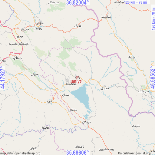
Ṟaniye GPS coordinates[2]
36° 15' 18.396" North, 44° 52' 56.604" East
| Map corner | latitude | longitude |
|---|---|---|
| Upper-left | 36.82004°, | 44.17927° |
| Center: | 36.25511°, | 44.88239° |
| Lower-right: | 35.68606°, | 45.58552° |
| Map W x H: | 126.1×126.1 km | = 78.4×78.4mi |
| max Lat: | 37.22781° ⇑20.4% North |
| Ṟaniye: | 36.25511° |
| min Lat: | ⇓79.6% South 29.97421° |
| min Long | Ṟaniye | max Long |
| 40.28586° | 44.88239° | 48.47309° |
| W 62.7%⇐ | ⇒37.3% E |
Elevation
Elevation of Ṟaniye is 574 m = 1883 ft, and this is 281 m = 922 ft above average elevation for this country.
| Max E: |
1316 m = 4318 ft | 19.7% |
| Ṟaniye | 574 m 1883 ft | |
| Avg. | 293 m = 961 ft | |
Min E: |
1 m = 3 ft | 80.3% |
See also: Iraq elevation on elevation.city.
Geographical zone
Ṟaniye is located in North temperate zone (between Tropic of Cancer and the Arctic Circle). Distance of this Northern Tropic circle is 1425.3 km =885.6 mi to South.| Distance of | km | miles | from Ṟaniye |
|---|---|---|---|
| North Pole | 5975.9 | 3713.3 | to North |
| Arctic Circle | 3370 | 2094 | to North |
| Tropic Cancer | 1425.3 | 885.6 | to South |
| Equator | 4031.2 | 2504.9 | to South |


Nearby cities:
15 places around Ṟaniye: (largest is in red/bold)
• Beḧirke
76.2 km =47.3 mi,  275°
275°
• Choman
42.4 km =26.3 mi,  0°
0°
• Dare Tû
75.3 km =46.8 mi,  258°
258°
• Dukan
36.9 km =22.9 mi,  168°
168°
• Halshaw
34.2 km =21.3 mi,  98°
98°
• Hayraw
38.7 km =24 mi,  111°
111°
• Hīrān
35 km =21.7 mi,  274°
274°
• Kasnazān
67.5 km =41.9 mi, 264°
• Koysinceq
29.8 km =18.5 mi,  229°
229°
• Mawet
61.9 km =38.5 mi,  129°
129°
• Nāḩiyat Hīrān
35.4 km =22 mi, 274°
• Qeładizê
23.6 km =14.7 mi, 109°
• Ruwāndiz
51 km =31.7 mi,  321°
321°
• Shaqlāwah
52.6 km =32.7 mi,  288°
288°
• Soran
53.6 km =33.3 mi,  325°
325°
Sources, notices
• [Note1] Compared only with cities in Iraq existing in our database
• [Src1] Map data: © OpenStreetMap contributors (CC-BY-SA)
• [Src2] Other city data from geonames.org with taken over terms of usage.
• [Src3] Geographical zone / Annual Mean Temperature by Robert A. Rohde @ Wikipedia
