Dukan geodata
Dukan (Sulaymaniyah) is a seat of a second-order administrative division; located in Iraq in Asia/Baghdad (GMT+3) time zone. In our database, there are 71 cities with bigger population. Compared to other cities in Iraq, 71.8% of cities are located further ↓South; 66.2% of cities are located further ←West and 71.1% of cities have lower elevation than Dukan. Note1


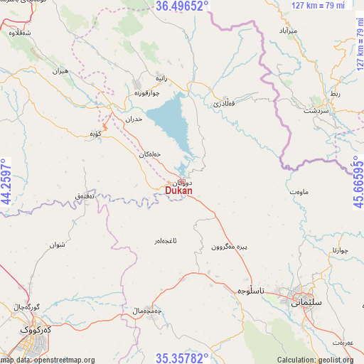
Dukan GPS coordinates[2]
35° 55' 45.192" North, 44° 57' 46.152" East
| Map corner | latitude | longitude |
|---|---|---|
| Upper-left | 36.49652°, | 44.2597° |
| Center: | 35.92922°, | 44.96282° |
| Lower-right: | 35.35782°, | 45.66595° |
| Map W x H: | 126.6×126.6 km | = 78.7×78.7mi |
| max Lat: | 37.22781° ⇑28.2% North |
| Dukan: | 35.92922° |
| min Lat: | ⇓71.8% South 29.97421° |
| min Long | Dukan | max Long |
| 40.28586° | 44.96282° | 48.47309° |
| W 66.2%⇐ | ⇒33.8% E |
Elevation
Elevation of Dukan is 423 m = 1388 ft, and this is 130 m = 427 ft above average elevation for this country.
| Max E: |
1316 m = 4318 ft | 28.9% |
| Dukan | 423 m 1388 ft | |
| Avg. | 293 m = 961 ft | |
Min E: |
1 m = 3 ft | 71.1% |
See also: Iraq elevation on elevation.city.
Geographical zone
Dukan is located in North temperate zone (between Tropic of Cancer and the Arctic Circle). Distance of this Northern Tropic circle is 1389 km =863.1 mi to South.| Distance of | km | miles | from Dukan |
|---|---|---|---|
| North Pole | 6012.1 | 3735.7 | to North |
| Arctic Circle | 3406.2 | 2116.5 | to North |
| Tropic Cancer | 1389 | 863.1 | to South |
| Equator | 3995 | 2482.4 | to South |


Nearby cities:
15 places around Dukan: (largest is in red/bold)
• As Sulaymānīyah
58.7 km =36.5 mi,  133°
133°
• Choman
78.9 km =49 mi,  355°
355°
• Chwarta
59.6 km =37 mi,  112°
112°
• Halshaw
41 km =25.5 mi,  40°
40°
• Hayraw
36.2 km =22.5 mi,  52°
52°
• Hīrān
57.3 km =35.6 mi,  312°
312°
• Jamjamāl
45.5 km =28.3 mi,  194°
194°
• Kirkuk
72.7 km =45.2 mi,  225°
225°
• Koysinceq
34.6 km =21.5 mi,  299°
299°
• Mawet
40.8 km =25.4 mi,  94°
94°
• Nāḩiyat Hīrān
57.7 km =35.9 mi, 312°
• Qeredagh
79.2 km =49.2 mi,  150°
150°
• Qeładizê
31.9 km =19.8 mi,  28°
28°
• Shaqlāwah
77.9 km =48.4 mi, 312°
• Ṟaniye
36.9 km =22.9 mi,  348°
348°
Sources, notices
• [Note1] Compared only with cities in Iraq existing in our database
• [Src1] Map data: © OpenStreetMap contributors (CC-BY-SA)
• [Src2] Other city data from geonames.org with taken over terms of usage.
• [Src3] Geographical zone / Annual Mean Temperature by Robert A. Rohde @ Wikipedia
