Abhar geodata
Abhar (Zanjan) is a seat of a second-order administrative division; located in Iran in Asia/Tehran (GMT+3.5) time zone. With population of 69,889 people, there are 94 cities with bigger population in this country. Compared to other cities in Iran, 69.6% of cities are located further ↓South; 69.2% of cities are located further →East and 72.6% of cities have lower elevation than Abhar. Note1


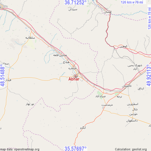
Abhar GPS coordinates[2]
36° 8' 48.48" North, 49° 13' 4.8" East
| Map corner | latitude | longitude |
|---|---|---|
| Upper-left | 36.71252°, | 48.51488° |
| Center: | 36.1468°, | 49.218° |
| Lower-right: | 35.57697°, | 49.92113° |
| Map W x H: | 126.3×126.3 km | = 78.5×78.5mi |
| max Lat: | 39.6482° ⇑30.4% North |
| Abhar: | 36.1468° |
| min Lat: | ⇓69.6% South 25.2919° |
| min Long | Abhar | max Long |
| 44.38416° | 49.218° | 61.9965° |
| W 30.8%⇐ | ⇒69.2% E |
Elevation
Elevation of Abhar is 1541 m = 5056 ft, and this is 492 m = 1614 ft above average elevation for this country.
| Max E: |
2564 m = 8412 ft | 27.4% |
| Abhar | 1541 m 5056 ft | |
| Avg. | 1049 m = 3442 ft | |
Min E: |
-24 m = -79 ft | 72.6% |
See also: Abhar elevation on elevation.city.
Geographical zone
Abhar is located in North temperate zone (between Tropic of Cancer and the Arctic Circle). Distance of this Northern Tropic circle is 1413.2 km =878.1 mi to South.| Distance of | km | miles | from Abhar |
|---|---|---|---|
| North Pole | 5987.9 | 3720.7 | to North |
| Arctic Circle | 3382 | 2101.5 | to North |
| Tropic Cancer | 1413.2 | 878.1 | to South |
| Equator | 4019.1 | 2497.4 | to South |


Nearby cities:
15 places around Abhar: (largest is in red/bold)
• Alvand
19.7 km =12.2 mi,  346°
346°
• Alvand
76.1 km =47.3 mi,  86°
86°
• Bū’īn Zahrā
86.6 km =53.8 mi,  119°
119°
• Eshtehārd
113.5 km =70.5 mi,  114°
114°
• Kabūdarāhang
113.4 km =70.5 mi,  203°
203°
• Khorramdarreh
7.1 km =4.4 mi,  343°
343°
• Māsūleh
113.9 km =70.8 mi, 349°
• Pādegān-e Manjīl
68.5 km =42.6 mi,  15°
15°
• Pā’īn-e Bāzār-e Rūdbār
77.3 km =48 mi,  13°
13°
• Qazvin
71.8 km =44.6 mi,  79°
79°
• Razan
86.2 km =53.6 mi,  191°
191°
• Tākestān
43.7 km =27.2 mi,  101°
101°
• Zanjān
87.4 km =54.3 mi,  312°
312°
• Zarrīnābād
89.5 km =55.6 mi,  290°
290°
• Ābbar
89.7 km =55.7 mi, 345°
Sources, notices
• [Note1] Compared only with cities in Iran existing in our database
• [Src1] Map data: © OpenStreetMap contributors (CC-BY-SA)
• [Src2] Other city data from geonames.org with taken over terms of usage.
• [Src3] Geographical zone / Annual Mean Temperature by Robert A. Rohde @ Wikipedia
