Semnan geodata
Semnan is a seat of a first-order administrative division; located in Iran in Asia/Tehran (GMT+3.5) time zone. With population of 124,826 people, there are 58 cities with bigger population in this country. Compared to other cities in Iran, 63.9% of cities are located further ↓South; 68.9% of cities are located further ←West and 51.9% of cities have higher elevation than Semnan. Note1


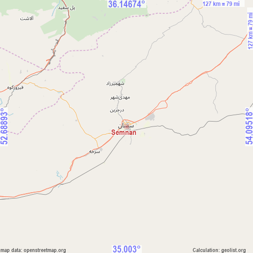
Semnan GPS coordinates[2]
35° 34' 36.876" North, 53° 23' 31.38" East
| Map corner | latitude | longitude |
|---|---|---|
| Upper-left | 36.14674°, | 52.68893° |
| Center: | 35.57691°, | 53.39205° |
| Lower-right: | 35.003°, | 54.09518° |
| Map W x H: | 127.2×127.2 km | = 79×79mi |
| max Lat: | 39.6482° ⇑36.1% North |
| Semnan: | 35.57691° |
| min Lat: | ⇓63.9% South 25.2919° |
| min Long | Semnan | max Long |
| 44.38416° | 53.39205° | 61.9965° |
| W 68.9%⇐ | ⇒31.1% E |
Elevation
Elevation of Semnan is 1148 m = 3766 ft, and this is 99 m = 325 ft above average elevation for this country.
| Max E: |
2564 m = 8412 ft | 51.9% |
| Semnan | 1148 m 3766 ft | |
| Avg. | 1049 m = 3442 ft | |
Min E: |
-24 m = -79 ft | 48.1% |
See also: Semnan elevation on elevation.city.
Geographical zone
Semnan is located in North temperate zone (between Tropic of Cancer and the Arctic Circle). Distance of this Northern Tropic circle is 1349.9 km =838.8 mi to South.| Distance of | km | miles | from Semnan |
|---|---|---|---|
| North Pole | 6051.3 | 3760.1 | to North |
| Arctic Circle | 3445.4 | 2140.9 | to North |
| Tropic Cancer | 1349.9 | 838.8 | to South |
| Equator | 3955.8 | 2458 | to South |


Nearby cities:
15 places around Semnan: (largest is in red/bold)
• Behshahr
124.9 km =77.6 mi,  6°
6°
• Damāvand
120.5 km =74.9 mi,  277°
277°
• Dāmghān
108 km =67.1 mi,  52°
52°
• Fīrūzkūh
59.6 km =37 mi,  289°
289°
• Garmsār
103.3 km =64.2 mi,  247°
247°
• Mahdishahr
15.3 km =9.5 mi,  346°
346°
• Nekā
119.7 km =74.4 mi,  355°
355°
• Pol-e Sefīd
67.4 km =41.9 mi,  333°
333°
• Qā’em Shahr
110.2 km =68.5 mi,  335°
335°
• Sari
113.7 km =70.6 mi, 344°
• Soleh Bon
78 km =48.5 mi, 285°
• Sorkheh
20.5 km =12.7 mi,  231°
231°
• Sūrak
114.4 km =71.1 mi, 351°
• Ārādān
89.1 km =55.4 mi, 245°
• Īstgāh-e Rāh Āhan-e Garmsār
105.2 km =65.4 mi, 248°
Sources, notices
• [Note1] Compared only with cities in Iran existing in our database
• [Src1] Map data: © OpenStreetMap contributors (CC-BY-SA)
• [Src2] Other city data from geonames.org with taken over terms of usage.
• [Src3] Geographical zone / Annual Mean Temperature by Robert A. Rohde @ Wikipedia
