Sorkheh geodata
Sorkheh (Semnan) is a seat of a second-order administrative division; located in Iran in Asia/Tehran (GMT+3.5) time zone. In our database, there are 232 cities with bigger population. Compared to other cities in Iran, 62.4% of cities are located further ↓South; 67.3% of cities are located further ←West and 52.4% of cities have higher elevation than Sorkheh. Note1


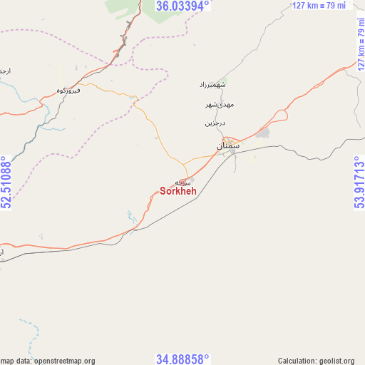
Sorkheh GPS coordinates[2]
35° 27' 47.88" North, 53° 12' 50.4" East
| Map corner | latitude | longitude |
|---|---|---|
| Upper-left | 36.03394°, | 52.51088° |
| Center: | 35.4633°, | 53.214° |
| Lower-right: | 34.88858°, | 53.91713° |
| Map W x H: | 127.4×127.4 km | = 79.2×79.2mi |
| max Lat: | 39.6482° ⇑37.6% North |
| Sorkheh: | 35.4633° |
| min Lat: | ⇓62.4% South 25.2919° |
| min Long | Sorkheh | max Long |
| 44.38416° | 53.214° | 61.9965° |
| W 67.3%⇐ | ⇒32.7% E |
Elevation
Elevation of Sorkheh is 1139 m = 3737 ft, and this is 90 m = 295 ft above average elevation for this country.
| Max E: |
2564 m = 8412 ft | 52.4% |
| Sorkheh | 1139 m 3737 ft | |
| Avg. | 1049 m = 3442 ft | |
Min E: |
-24 m = -79 ft | 47.6% |
See also: Iran elevation on elevation.city.
Geographical zone
Sorkheh is located in North temperate zone (between Tropic of Cancer and the Arctic Circle). Distance of this Northern Tropic circle is 1337.2 km =830.9 mi to South.| Distance of | km | miles | from Sorkheh |
|---|---|---|---|
| North Pole | 6063.9 | 3767.9 | to North |
| Arctic Circle | 3458 | 2148.7 | to North |
| Tropic Cancer | 1337.2 | 830.9 | to South |
| Equator | 3943.1 | 2450.1 | to South |


Nearby cities:
15 places around Sorkheh: (largest is in red/bold)
• Bābol
130.2 km =80.9 mi,  338°
338°
• Damāvand
107.3 km =66.7 mi,  285°
285°
• Dāmghān
128.4 km =79.8 mi,  52°
52°
• Fīrūzkūh
51.7 km =32.1 mi,  309°
309°
• Garmsār
83.8 km =52.1 mi,  251°
251°
• Mahdishahr
30.3 km =18.8 mi,  24°
24°
• Pol-e Sefīd
74.2 km =46.1 mi,  348°
348°
• Qā’em Shahr
116.9 km =72.6 mi, 345°
• Sari
123.1 km =76.5 mi, 353°
• Semnan
20.5 km =12.7 mi, 51°
• Sharīfābād
129.5 km =80.5 mi,  268°
268°
• Soleh Bon
68.1 km =42.3 mi,  299°
299°
• Sūrak
125.8 km =78.2 mi,  359°
359°
• Ārādān
69.5 km =43.2 mi, 249°
• Īstgāh-e Rāh Āhan-e Garmsār
85.9 km =53.4 mi, 252°
Sources, notices
• [Note1] Compared only with cities in Iran existing in our database
• [Src1] Map data: © OpenStreetMap contributors (CC-BY-SA)
• [Src2] Other city data from geonames.org with taken over terms of usage.
• [Src3] Geographical zone / Annual Mean Temperature by Robert A. Rohde @ Wikipedia
