Ārādān geodata
Ārādān (Semnan) is a seat of a second-order administrative division; located in Iran in Asia/Tehran (GMT+3.5) time zone. In our database, there are 232 cities with bigger population. Compared to other cities in Iran, 58.7% of cities are located further ↓South; 61.2% of cities are located further ←West and 64.6% of cities have higher elevation than Ārādān. Note1


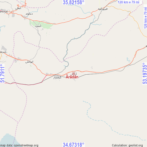
Ārādān GPS coordinates[2]
35° 14' 57.876" North, 52° 29' 39.192" East
| Map corner | latitude | longitude |
|---|---|---|
| Upper-left | 35.82158°, | 51.7911° |
| Center: | 35.24941°, | 52.49422° |
| Lower-right: | 34.67318°, | 53.19735° |
| Map W x H: | 127.7×127.7 km | = 79.3×79.3mi |
| max Lat: | 39.6482° ⇑41.3% North |
| Ārādān: | 35.24941° |
| min Lat: | ⇓58.7% South 25.2919° |
| min Long | Ārādān | max Long |
| 44.38416° | 52.49422° | 61.9965° |
| W 61.2%⇐ | ⇒38.8% E |
Elevation
Elevation of Ārādān is 874 m = 2867 ft, and this is 175 m = 574 ft below average elevation for this country.
| Max E: |
2564 m = 8412 ft | 64.6% |
| Avg. | 1049 m = 3442 ft | |
| Ārādān | 874 m = 2867 ft | |
Min E: |
-24 m = -79 ft | 35.4% |
See also: Iran elevation on elevation.city.
Geographical zone
Ārādān is located in North temperate zone (between Tropic of Cancer and the Arctic Circle). Distance of this Northern Tropic circle is 1313.4 km =816.1 mi to South.| Distance of | km | miles | from Ārādān |
|---|---|---|---|
| North Pole | 6087.7 | 3782.7 | to North |
| Arctic Circle | 3481.8 | 2163.5 | to North |
| Tropic Cancer | 1313.4 | 816.1 | to South |
| Equator | 3919.4 | 2435.4 | to South |


Nearby cities:
15 places around Ārādān: (largest is in red/bold)
• Damāvand
64.8 km =40.3 mi,  323°
323°
• Eqbālīyeh
87.2 km =54.2 mi,  273°
273°
• Fīrūzkūh
61.7 km =38.3 mi,  23°
23°
• Garmsār
14.4 km =8.9 mi,  256°
256°
• Mahdishahr
93.2 km =57.9 mi,  56°
56°
• Pākdasht
77.8 km =48.3 mi,  289°
289°
• Pīshvā
70 km =43.5 mi,  275°
275°
• Qarchak
85.7 km =53.3 mi, 283°
• Semnan
89.1 km =55.4 mi,  65°
65°
• Sharīfābād
67.3 km =41.8 mi, 287°
• Soleh Bon
58 km =36 mi,  5°
5°
• Sorkheh
69.5 km =43.2 mi, 69°
• Varāmīn
77.5 km =48.2 mi, 276°
• Īstgāh-e Rāh Āhan-e Garmsār
16.9 km =10.5 mi, 264°
• Ţāleb ābād
91.7 km =57 mi, 287°
Sources, notices
• [Note1] Compared only with cities in Iran existing in our database
• [Src1] Map data: © OpenStreetMap contributors (CC-BY-SA)
• [Src2] Other city data from geonames.org with taken over terms of usage.
• [Src3] Geographical zone / Annual Mean Temperature by Robert A. Rohde @ Wikipedia
