Chenārān geodata
Chenārān (Razavi Khorasan) is a seat of a second-order administrative division; located in Iran in Asia/Tehran (GMT+3.5) time zone. With population of 46,940 people, there are 140 cities with bigger population in this country. Compared to other cities in Iran, 76.2% of cities are located further ↓South; 92.3% of cities are located further ←West and 50.1% of cities have lower elevation than Chenārān. Note1


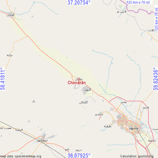
Chenārān GPS coordinates[2]
36° 38' 43.656" North, 59° 7' 16.428" East
| Map corner | latitude | longitude |
|---|---|---|
| Upper-left | 37.20754°, | 58.41811° |
| Center: | 36.64546°, | 59.12123° |
| Lower-right: | 36.07925°, | 59.82436° |
| Map W x H: | 125.5×125.5 km | = 78×78mi |
| max Lat: | 39.6482° ⇑23.8% North |
| Chenārān: | 36.64546° |
| min Lat: | ⇓76.2% South 25.2919° |
| min Long | Chenārān | max Long |
| 44.38416° | 59.12123° | 61.9965° |
| W 92.3%⇐ | ⇒7.7% E |
Elevation
Elevation of Chenārān is 1176 m = 3858 ft, and this is 127 m = 417 ft above average elevation for this country.
| Max E: |
2564 m = 8412 ft | 49.9% |
| Chenārān | 1176 m 3858 ft | |
| Avg. | 1049 m = 3442 ft | |
Min E: |
-24 m = -79 ft | 50.1% |
See also: Chenārān elevation on elevation.city.
Geographical zone
Chenārān is located in North temperate zone (between Tropic of Cancer and the Arctic Circle). Distance of this Northern Tropic circle is 1468.7 km =912.6 mi to South.| Distance of | km | miles | from Chenārān |
|---|---|---|---|
| North Pole | 5932.5 | 3686.3 | to North |
| Arctic Circle | 3326.6 | 2067.1 | to North |
| Tropic Cancer | 1468.7 | 912.6 | to South |
| Equator | 4074.6 | 2531.8 | to South |


Nearby cities:
15 places around Chenārān: (largest is in red/bold)
• Bozghān
62.3 km =38.7 mi,  230°
230°
• Dargaz
88.8 km =55.2 mi,  359°
359°
• Esfarāyen
151.1 km =93.9 mi,  288°
288°
• Farīmān
123.2 km =76.6 mi,  147°
147°
• Fārūj
103.3 km =64.2 mi,  309°
309°
• Kalāt-e Nāderī
69.2 km =43 mi,  55°
55°
• Mashhad
54.2 km =33.7 mi,  132°
132°
• Neqāb
151.7 km =94.3 mi,  272°
272°
• Neyshābūr
56.2 km =34.9 mi,  211°
211°
• Qūchān
74.7 km =46.4 mi, 313°
• Sabzevar
137.5 km =85.4 mi,  249°
249°
• Shīrvān
134.8 km =83.8 mi, 308°
• Solţānābād
100.4 km =62.4 mi, 254°
• Torbat-e Ḩeydarīyeh
152.7 km =94.9 mi,  176°
176°
• Ţorqabeh
43.6 km =27.1 mi, 148°
Sources, notices
• [Note1] Compared only with cities in Iran existing in our database
• [Src1] Map data: © OpenStreetMap contributors (CC-BY-SA)
• [Src2] Other city data from geonames.org with taken over terms of usage.
• [Src3] Geographical zone / Annual Mean Temperature by Robert A. Rohde @ Wikipedia
