Mashhad geodata
Mashhad (Razavi Khorasan) is a seat of a first-order administrative division; located in Iran in Asia/Tehran (GMT+3.5) time zone. With population of 2,307,177 people, there is 1 city with bigger population in this country. Compared to other cities in Iran, 72.3% of cities are located further ↓South; 93.9% of cities are located further ←West and 58.3% of cities have higher elevation than Mashhad. Note1


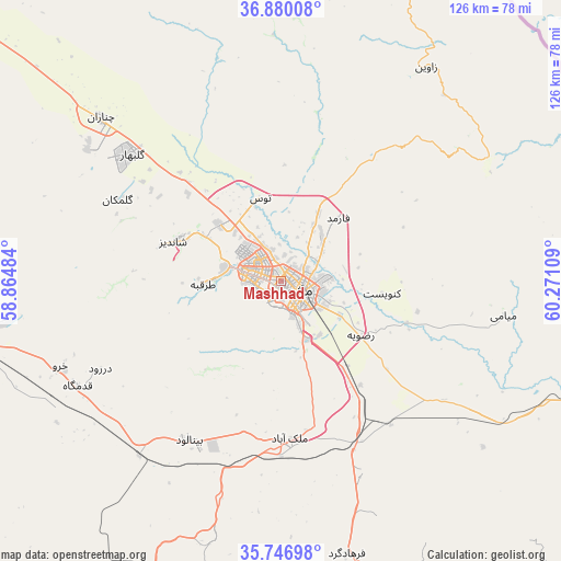
Mashhad GPS coordinates[2]
36° 18' 56.124" North, 59° 34' 4.656" East
| Map corner | latitude | longitude |
|---|---|---|
| Upper-left | 36.88008°, | 58.86484° |
| Center: | 36.31559°, | 59.56796° |
| Lower-right: | 35.74698°, | 60.27109° |
| Map W x H: | 126×126 km | = 78.3×78.3mi |
| max Lat: | 39.6482° ⇑27.7% North |
| Mashhad: | 36.31559° |
| min Lat: | ⇓72.3% South 25.2919° |
| min Long | Mashhad | max Long |
| 44.38416° | 59.56796° | 61.9965° |
| W 93.9%⇐ | ⇒6.1% E |
Elevation
Elevation of Mashhad is 1003 m = 3291 ft, and this is 46 m = 151 ft below average elevation for this country.
| Max E: |
2564 m = 8412 ft | 58.3% |
| Avg. | 1049 m = 3442 ft | |
| Mashhad | 1003 m = 3291 ft | |
Min E: |
-24 m = -79 ft | 41.7% |
See also: Mashhad elevation on elevation.city.
Geographical zone
Mashhad is located in North temperate zone (between Tropic of Cancer and the Arctic Circle). Distance of this Northern Tropic circle is 1432 km =889.8 mi to South.| Distance of | km | miles | from Mashhad |
|---|---|---|---|
| North Pole | 5969.1 | 3709 | to North |
| Arctic Circle | 3363.3 | 2089.9 | to North |
| Tropic Cancer | 1432 | 889.8 | to South |
| Equator | 4037.9 | 2509 | to South |


Nearby cities:
15 places around Mashhad: (largest is in red/bold)
• Bozghān
88.1 km =54.7 mi,  267°
267°
• Chenārān
54.2 km =33.7 mi,  312°
312°
• Dargaz
132 km =82 mi,  341°
341°
• Dowlatābād
115 km =71.5 mi,  182°
182°
• Farīmān
72.3 km =44.9 mi,  159°
159°
• Kalāt-e Nāderī
77.6 km =48.2 mi,  13°
13°
• Kāshmar
155.7 km =96.7 mi,  219°
219°
• Neyshābūr
70.2 km =43.6 mi,  260°
260°
• Qūchān
128.9 km =80.1 mi, 312°
• Roshtkhvār
149.1 km =92.6 mi, 178°
• Sarakhs
144.5 km =89.8 mi,  79°
79°
• Solţānābād
137.3 km =85.3 mi, 274°
• Torbat-e Jām
152.5 km =94.8 mi,  141°
141°
• Torbat-e Ḩeydarīyeh
120 km =74.6 mi,  195°
195°
• Ţorqabeh
17.4 km =10.8 mi, 268°
Sources, notices
• [Note1] Compared only with cities in Iran existing in our database
• [Src1] Map data: © OpenStreetMap contributors (CC-BY-SA)
• [Src2] Other city data from geonames.org with taken over terms of usage.
• [Src3] Geographical zone / Annual Mean Temperature by Robert A. Rohde @ Wikipedia
