Pāveh geodata
Pāveh (Kermānshāh) is a seat of a second-order administrative division; located in Iran in Asia/Tehran (GMT+3.5) time zone. With population of 17,779 people, there are 197 cities with bigger population in this country. Compared to other cities in Iran, 56.9% of cities are located further ↓South; 91.6% of cities are located further →East and 71.9% of cities have lower elevation than Pāveh. Note1


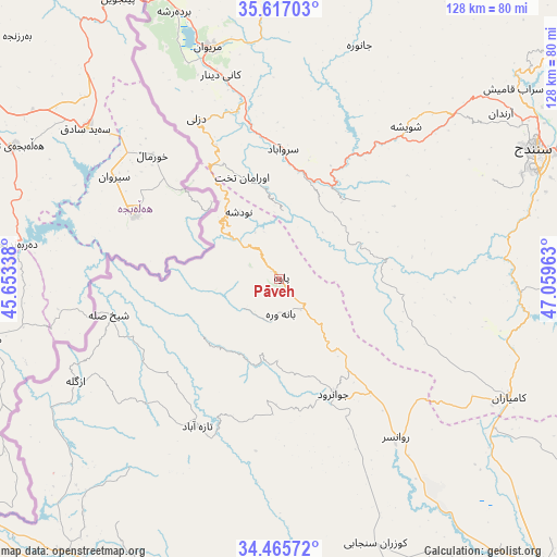
Pāveh GPS coordinates[2]
35° 2' 36.24" North, 46° 21' 23.4" East
| Map corner | latitude | longitude |
|---|---|---|
| Upper-left | 35.61703°, | 45.65338° |
| Center: | 35.0434°, | 46.3565° |
| Lower-right: | 34.46572°, | 47.05963° |
| Map W x H: | 128×128 km | = 79.5×79.5mi |
| max Lat: | 39.6482° ⇑43.1% North |
| Pāveh: | 35.0434° |
| min Lat: | ⇓56.9% South 25.2919° |
| min Long | Pāveh | max Long |
| 44.38416° | 46.3565° | 61.9965° |
| W 8.4%⇐ | ⇒91.6% E |
Elevation
Elevation of Pāveh is 1525 m = 5003 ft, and this is 476 m = 1562 ft above average elevation for this country.
| Max E: |
2564 m = 8412 ft | 28.1% |
| Pāveh | 1525 m 5003 ft | |
| Avg. | 1049 m = 3442 ft | |
Min E: |
-24 m = -79 ft | 71.9% |
See also: Iran elevation on elevation.city.
Geographical zone
Pāveh is located in North temperate zone (between Tropic of Cancer and the Arctic Circle). Distance of this Northern Tropic circle is 1290.5 km =801.9 mi to South.| Distance of | km | miles | from Pāveh |
|---|---|---|---|
| North Pole | 6110.6 | 3796.9 | to North |
| Arctic Circle | 3504.7 | 2177.7 | to North |
| Tropic Cancer | 1290.5 | 801.9 | to South |
| Equator | 3896.5 | 2421.2 | to South |


Nearby cities:
15 places around Pāveh: (largest is in red/bold)
• Dehgolān
100 km =62.1 mi,  74°
74°
• Eslāmābād-e Gharb
105 km =65.2 mi,  171°
171°
• Javānrūd
29 km =18 mi,  154°
154°
• Javānrūd
31.2 km =19.4 mi, 151°
• Kahrīz
97.3 km =60.5 mi,  138°
138°
• Kerend-e Gharb
85.1 km =52.9 mi,  187°
187°
• Kermanshah
103.8 km =64.5 mi, 141°
• Kāmyārān
59.5 km =37 mi,  117°
117°
• Marīvān
55.1 km =34.2 mi,  343°
343°
• Qaşr-e Shīrīn
92.1 km =57.2 mi,  230°
230°
• Ravānsar
45.4 km =28.2 mi, 143°
• Sanandaj
65.7 km =40.8 mi,  62°
62°
• Sarpol-e Z̄ahāb
78.9 km =49 mi,  214°
214°
• Sarvābād
29.9 km =18.6 mi,  1°
1°
• Tāzehābād
38.8 km =24.1 mi, 209°
Sources, notices
• [Note1] Compared only with cities in Iran existing in our database
• [Src1] Map data: © OpenStreetMap contributors (CC-BY-SA)
• [Src2] Other city data from geonames.org with taken over terms of usage.
• [Src3] Geographical zone / Annual Mean Temperature by Robert A. Rohde @ Wikipedia
