Marīvān geodata
Marīvān (Kordestān) is a seat of a second-order administrative division; located in Iran in Asia/Tehran (GMT+3.5) time zone. With population of 91,664 people, there are 76 cities with bigger population in this country. Compared to other cities in Iran, 63.5% of cities are located further ↓South; 93.4% of cities are located further →East and 58.3% of cities have lower elevation than Marīvān. Note1


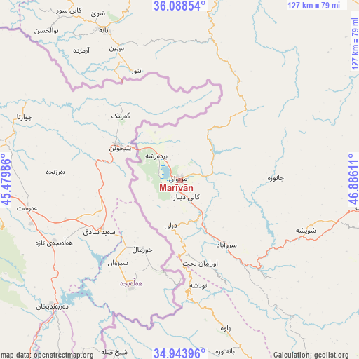
Marīvān GPS coordinates[2]
35° 31' 5.844" North, 46° 10' 58.728" East
| Map corner | latitude | longitude |
|---|---|---|
| Upper-left | 36.08854°, | 45.47986° |
| Center: | 35.51829°, | 46.18298° |
| Lower-right: | 34.94396°, | 46.88611° |
| Map W x H: | 127.3×127.3 km | = 79.1×79.1mi |
| max Lat: | 39.6482° ⇑36.5% North |
| Marīvān: | 35.51829° |
| min Lat: | ⇓63.5% South 25.2919° |
| min Long | Marīvān | max Long |
| 44.38416° | 46.18298° | 61.9965° |
| W 6.6%⇐ | ⇒93.4% E |
Elevation
Elevation of Marīvān is 1306 m = 4285 ft, and this is 257 m = 843 ft above average elevation for this country.
| Max E: |
2564 m = 8412 ft | 41.7% |
| Marīvān | 1306 m 4285 ft | |
| Avg. | 1049 m = 3442 ft | |
Min E: |
-24 m = -79 ft | 58.3% |
See also: Marīvān elevation on elevation.city.
Geographical zone
Marīvān is located in North temperate zone (between Tropic of Cancer and the Arctic Circle). Distance of this Northern Tropic circle is 1343.3 km =834.7 mi to South.| Distance of | km | miles | from Marīvān |
|---|---|---|---|
| North Pole | 6057.8 | 3764.1 | to North |
| Arctic Circle | 3451.9 | 2144.9 | to North |
| Tropic Cancer | 1343.3 | 834.7 | to South |
| Equator | 3949.3 | 2454 | to South |


Nearby cities:
15 places around Marīvān: (largest is in red/bold)
• Bāneh
59.7 km =37.1 mi,  333°
333°
• Būkān
111.5 km =69.3 mi,  1°
1°
• Dehgolān
115.1 km =71.5 mi,  103°
103°
• Dīvāndarreh
87.7 km =54.5 mi,  59°
59°
• Javānrūd
83.9 km =52.1 mi,  160°
160°
• Javānrūd
85.9 km =53.4 mi, 159°
• Kāmyārān
105.5 km =65.6 mi,  139°
139°
• Pāveh
55.1 km =34.2 mi, 163°
• Ravānsar
99 km =61.5 mi,  154°
154°
• Sanandaj
77.3 km =48 mi,  107°
107°
• Saqqez
81.8 km =50.8 mi,  5°
5°
• Sardasht
95.1 km =59.1 mi,  318°
318°
• Sarpol-e Z̄ahāb
121.1 km =75.2 mi,  193°
193°
• Sarvābād
28.3 km =17.6 mi, 143°
• Tāzehābād
86.7 km =53.9 mi,  182°
182°
Sources, notices
• [Note1] Compared only with cities in Iran existing in our database
• [Src1] Map data: © OpenStreetMap contributors (CC-BY-SA)
• [Src2] Other city data from geonames.org with taken over terms of usage.
• [Src3] Geographical zone / Annual Mean Temperature by Robert A. Rohde @ Wikipedia
