Sanandaj geodata
Sanandaj (Kordestān) is a seat of a first-order administrative division; located in Iran in Asia/Tehran (GMT+3.5) time zone. With population of 349,176 people, there are 23 cities with bigger population in this country. Compared to other cities in Iran, 61% of cities are located further ↓South; 88.9% of cities are located further →East and 69.4% of cities have lower elevation than Sanandaj. Note1


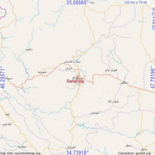
Sanandaj GPS coordinates[2]
35° 18' 53.82" North, 46° 59' 55.788" East
| Map corner | latitude | longitude |
|---|---|---|
| Upper-left | 35.88665°, | 46.29571° |
| Center: | 35.31495°, | 46.99883° |
| Lower-right: | 34.73918°, | 47.70196° |
| Map W x H: | 127.6×127.6 km | = 79.3×79.3mi |
| max Lat: | 39.6482° ⇑39% North |
| Sanandaj: | 35.31495° |
| min Lat: | ⇓61% South 25.2919° |
| min Long | Sanandaj | max Long |
| 44.38416° | 46.99883° | 61.9965° |
| W 11.1%⇐ | ⇒88.9% E |
Elevation
Elevation of Sanandaj is 1494 m = 4902 ft, and this is 445 m = 1460 ft above average elevation for this country.
| Max E: |
2564 m = 8412 ft | 30.6% |
| Sanandaj | 1494 m 4902 ft | |
| Avg. | 1049 m = 3442 ft | |
Min E: |
-24 m = -79 ft | 69.4% |
See also: Sanandaj elevation on elevation.city.
Geographical zone
Sanandaj is located in North temperate zone (between Tropic of Cancer and the Arctic Circle). Distance of this Northern Tropic circle is 1320.7 km =820.6 mi to South.| Distance of | km | miles | from Sanandaj |
|---|---|---|---|
| North Pole | 6080.4 | 3778.2 | to North |
| Arctic Circle | 3474.5 | 2159 | to North |
| Tropic Cancer | 1320.7 | 820.6 | to South |
| Equator | 3926.7 | 2439.9 | to South |


Nearby cities:
15 places around Sanandaj: (largest is in red/bold)
• Bījār
82.3 km =51.1 mi,  41°
41°
• Dehgolān
38.3 km =23.8 mi,  96°
96°
• Dīvāndarreh
66.6 km =41.4 mi,  1°
1°
• Javānrūd
72.5 km =45 mi,  217°
217°
• Javānrūd
73 km =45.4 mi, 219°
• Kahrīz
103.7 km =64.4 mi,  177°
177°
• Kāmyārān
58 km =36 mi,  185°
185°
• Marīvān
77.3 km =48 mi,  287°
287°
• Pāveh
65.7 km =40.8 mi,  242°
242°
• Qohūrd-e ‘Olyā
98.4 km =61.1 mi,  81°
81°
• Qorveh
75.1 km =46.7 mi, 102°
• Ravānsar
73.7 km =45.8 mi,  205°
205°
• Sarvābād
57.3 km =35.6 mi,  269°
269°
• Sonqor
80.6 km =50.1 mi,  137°
137°
• Tāzehābād
100.4 km =62.4 mi,  230°
230°
Sources, notices
• [Note1] Compared only with cities in Iran existing in our database
• [Src1] Map data: © OpenStreetMap contributors (CC-BY-SA)
• [Src2] Other city data from geonames.org with taken over terms of usage.
• [Src3] Geographical zone / Annual Mean Temperature by Robert A. Rohde @ Wikipedia
