Sarvābād geodata
Sarvābād (Kordestān) is a seat of a second-order administrative division; located in Iran in Asia/Tehran (GMT+3.5) time zone. In our database, there are 232 cities with bigger population. Compared to other cities in Iran, 60.8% of cities are located further ↓South; 91.4% of cities are located further →East and 51.7% of cities have lower elevation than Sarvābād. Note1


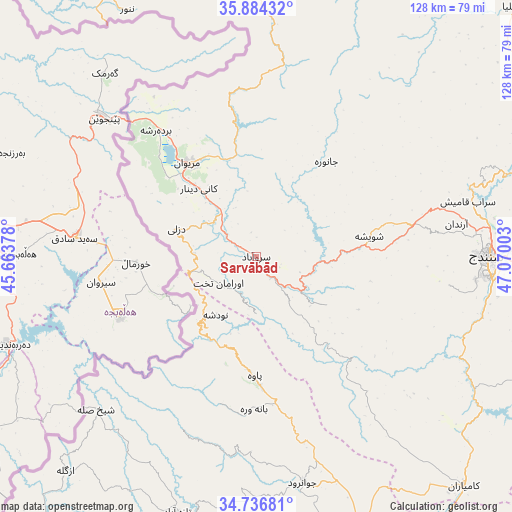
Sarvābād GPS coordinates[2]
35° 18' 45.36" North, 46° 22' 0.84" East
| Map corner | latitude | longitude |
|---|---|---|
| Upper-left | 35.88432°, | 45.66378° |
| Center: | 35.3126°, | 46.3669° |
| Lower-right: | 34.73681°, | 47.07003° |
| Map W x H: | 127.6×127.6 km | = 79.3×79.3mi |
| max Lat: | 39.6482° ⇑39.2% North |
| Sarvābād: | 35.3126° |
| min Lat: | ⇓60.8% South 25.2919° |
| min Long | Sarvābād | max Long |
| 44.38416° | 46.3669° | 61.9965° |
| W 8.6%⇐ | ⇒91.4% E |
Elevation
Elevation of Sarvābād is 1184 m = 3885 ft, and this is 135 m = 443 ft above average elevation for this country.
| Max E: |
2564 m = 8412 ft | 48.3% |
| Sarvābād | 1184 m 3885 ft | |
| Avg. | 1049 m = 3442 ft | |
Min E: |
-24 m = -79 ft | 51.7% |
See also: Iran elevation on elevation.city.
Geographical zone
Sarvābād is located in North temperate zone (between Tropic of Cancer and the Arctic Circle). Distance of this Northern Tropic circle is 1320.5 km =820.5 mi to South.| Distance of | km | miles | from Sarvābād |
|---|---|---|---|
| North Pole | 6080.7 | 3778.4 | to North |
| Arctic Circle | 3474.8 | 2159.1 | to North |
| Tropic Cancer | 1320.5 | 820.5 | to South |
| Equator | 3926.4 | 2439.8 | to South |


Nearby cities:
15 places around Sarvābād: (largest is in red/bold)
• Bāneh
87.7 km =54.5 mi,  330°
330°
• Dehgolān
95.5 km =59.3 mi,  92°
92°
• Dīvāndarreh
89.4 km =55.6 mi,  41°
41°
• Javānrūd
57.4 km =35.7 mi,  168°
168°
• Javānrūd
59 km =36.7 mi, 166°
• Kerend-e Gharb
114.9 km =71.4 mi,  185°
185°
• Kāmyārān
77.3 km =48 mi,  138°
138°
• Marīvān
28.3 km =17.6 mi,  323°
323°
• Pāveh
29.9 km =18.6 mi,  181°
181°
• Qaşr-e Shīrīn
114.1 km =70.9 mi,  219°
219°
• Ravānsar
71.4 km =44.4 mi,  158°
158°
• Sanandaj
57.3 km =35.6 mi, 89°
• Saqqez
104.6 km =65 mi,  355°
355°
• Sarpol-e Z̄ahāb
105.3 km =65.4 mi,  205°
205°
• Tāzehābād
66.8 km =41.5 mi,  197°
197°
Sources, notices
• [Note1] Compared only with cities in Iran existing in our database
• [Src1] Map data: © OpenStreetMap contributors (CC-BY-SA)
• [Src2] Other city data from geonames.org with taken over terms of usage.
• [Src3] Geographical zone / Annual Mean Temperature by Robert A. Rohde @ Wikipedia
