Farīmān geodata
Farīmān (Razavi Khorasan) is a seat of a second-order administrative division; located in Iran in Asia/Tehran (GMT+3.5) time zone. In our database, there are 232 cities with bigger population. Compared to other cities in Iran, 65.3% of cities are located further ↓South; 95.2% of cities are located further ←West and 64.9% of cities have lower elevation than Farīmān. Note1


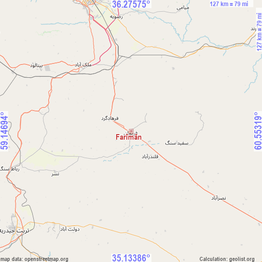
Farīmān GPS coordinates[2]
35° 42' 24.66" North, 59° 51' 0.216" East
| Map corner | latitude | longitude |
|---|---|---|
| Upper-left | 36.27575°, | 59.14694° |
| Center: | 35.70685°, | 59.85006° |
| Lower-right: | 35.13386°, | 60.55319° |
| Map W x H: | 127×127 km | = 78.9×78.9mi |
| max Lat: | 39.6482° ⇑34.7% North |
| Farīmān: | 35.70685° |
| min Lat: | ⇓65.3% South 25.2919° |
| min Long | Farīmān | max Long |
| 44.38416° | 59.85006° | 61.9965° |
| W 95.2%⇐ | ⇒4.8% E |
Elevation
Elevation of Farīmān is 1398 m = 4587 ft, and this is 349 m = 1145 ft above average elevation for this country.
| Max E: |
2564 m = 8412 ft | 35.1% |
| Farīmān | 1398 m 4587 ft | |
| Avg. | 1049 m = 3442 ft | |
Min E: |
-24 m = -79 ft | 64.9% |
See also: Iran elevation on elevation.city.
Geographical zone
Farīmān is located in North temperate zone (between Tropic of Cancer and the Arctic Circle). Distance of this Northern Tropic circle is 1364.3 km =847.7 mi to South.| Distance of | km | miles | from Farīmān |
|---|---|---|---|
| North Pole | 6036.8 | 3751.1 | to North |
| Arctic Circle | 3430.9 | 2131.9 | to North |
| Tropic Cancer | 1364.3 | 847.7 | to South |
| Equator | 3970.2 | 2467 | to South |


Nearby cities:
15 places around Farīmān: (largest is in red/bold)
• Bozghān
130.7 km =81.2 mi,  299°
299°
• Chenārān
123.2 km =76.6 mi,  327°
327°
• Dowlatābād
55.9 km =34.7 mi,  212°
212°
• Feyẕābād
123.3 km =76.6 mi,  231°
231°
• Kalāt-e Nāderī
143.5 km =89.2 mi,  356°
356°
• Khvāf
128.5 km =79.8 mi,  168°
168°
• Kāshmar
135.8 km =84.4 mi,  247°
247°
• Mashhad
72.3 km =44.9 mi,  339°
339°
• Neyshābūr
110.3 km =68.5 mi, 300°
• Roshtkhvār
83.9 km =52.1 mi,  194°
194°
• Shahrak-e Bākharz
90.1 km =56 mi,  151°
151°
• Torbat-e Jām
86.8 km =53.9 mi,  126°
126°
• Torbat-e Ḩeydarīyeh
74.7 km =46.4 mi, 229°
• Tāybād
136.5 km =84.8 mi,  141°
141°
• Ţorqabeh
79.6 km =49.5 mi, 327°
Sources, notices
• [Note1] Compared only with cities in Iran existing in our database
• [Src1] Map data: © OpenStreetMap contributors (CC-BY-SA)
• [Src2] Other city data from geonames.org with taken over terms of usage.
• [Src3] Geographical zone / Annual Mean Temperature by Robert A. Rohde @ Wikipedia
