Torbat-e Ḩeydarīyeh geodata
Torbat-e Ḩeydarīyeh (Razavi Khorasan) is a seat of a second-order administrative division; located in Iran in Asia/Tehran (GMT+3.5) time zone. With population of 125,633 people, there are 57 cities with bigger population in this country. Compared to other cities in Iran, 59.4% of cities are located further ↓South; 92.7% of cities are located further ←West and 61.5% of cities have lower elevation than Torbat-e Ḩeydarīyeh. Note1


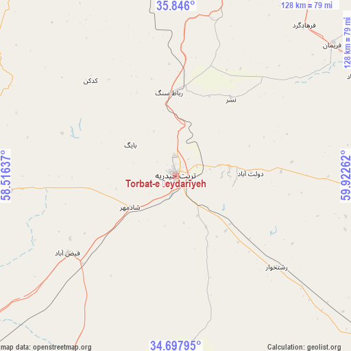
Torbat-e Ḩeydarīyeh GPS coordinates[2]
35° 16' 26.436" North, 59° 13' 10.164" East
| Map corner | latitude | longitude |
|---|---|---|
| Upper-left | 35.846°, | 58.51637° |
| Center: | 35.27401°, | 59.21949° |
| Lower-right: | 34.69795°, | 59.92262° |
| Map W x H: | 127.7×127.7 km | = 79.3×79.3mi |
| max Lat: | 39.6482° ⇑40.6% North |
| Torbat-e Ḩeydarīyeh: | 35.27401° |
| min Lat: | ⇓59.4% South 25.2919° |
| min Long | Torbat-e Ḩeyd | max Long |
| 44.38416° | 59.21949° | 61.9965° |
| W 92.7%⇐ | ⇒7.3% E |
Elevation
Elevation of Torbat-e Ḩeydarīyeh is 1351 m = 4432 ft, and this is 302 m = 991 ft above average elevation for this country.
| Max E: |
2564 m = 8412 ft | 38.5% |
| Torbat-e Ḩeydarīyeh | 1351 m 4432 ft | |
| Avg. | 1049 m = 3442 ft | |
Min E: |
-24 m = -79 ft | 61.5% |
See also: Torbat-e Ḩeydarīyeh elevation on elevation.city.
Geographical zone
Torbat-e Ḩeydarīyeh is located in North temperate zone (between Tropic of Cancer and the Arctic Circle). Distance of this Northern Tropic circle is 1316.2 km =817.8 mi to South.| Distance of | km | miles | from Torbat-e Ḩeydarīyeh |
|---|---|---|---|
| North Pole | 6085 | 3781 | to North |
| Arctic Circle | 3479.1 | 2161.8 | to North |
| Tropic Cancer | 1316.2 | 817.8 | to South |
| Equator | 3922.1 | 2437.1 | to South |


Nearby cities:
15 places around Torbat-e Ḩeydarīyeh: (largest is in red/bold)
• Bajestān
126.5 km =78.6 mi,  228°
228°
• Bardaskan
113.4 km =70.5 mi,  269°
269°
• Bozghān
126.2 km =78.4 mi,  333°
333°
• Dowlatābād
27.3 km =17 mi,  88°
88°
• Farīmān
74.7 km =46.4 mi,  49°
49°
• Feyẕābād
48.7 km =30.3 mi, 234°
• Gonābād
113.5 km =70.5 mi,  205°
205°
• Khalīlābād
84.8 km =52.7 mi, 268°
• Khvāf
114.3 km =71 mi,  132°
132°
• Kāshmar
68.6 km =42.6 mi, 266°
• Mashhad
120 km =74.6 mi,  15°
15°
• Neyshābūr
111.2 km =69.1 mi,  339°
339°
• Roshtkhvār
49.6 km =30.8 mi, 132°
• Shahrak-e Bākharz
104.6 km =65 mi,  107°
107°
• Ţorqabeh
116.1 km =72.1 mi,  6°
6°
Sources, notices
• [Note1] Compared only with cities in Iran existing in our database
• [Src1] Map data: © OpenStreetMap contributors (CC-BY-SA)
• [Src2] Other city data from geonames.org with taken over terms of usage.
• [Src3] Geographical zone / Annual Mean Temperature by Robert A. Rohde @ Wikipedia
