Bardaskan geodata
Bardaskan (Razavi Khorasan) is a seat of a second-order administrative division; located in Iran in Asia/Tehran (GMT+3.5) time zone. With population of 28,233 people, there are 180 cities with bigger population in this country. Compared to other cities in Iran, 59.2% of cities are located further ↓South; 88% of cities are located further ←West and 59.6% of cities have higher elevation than Bardaskan. Note1


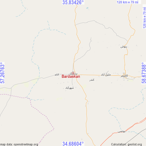
Bardaskan GPS coordinates[2]
35° 15' 43.848" North, 57° 58' 14.7" East
| Map corner | latitude | longitude |
|---|---|---|
| Upper-left | 35.83426°, | 57.26763° |
| Center: | 35.26218°, | 57.97075° |
| Lower-right: | 34.68604°, | 58.67388° |
| Map W x H: | 127.7×127.7 km | = 79.3×79.3mi |
| max Lat: | 39.6482° ⇑40.8% North |
| Bardaskan: | 35.26218° |
| min Lat: | ⇓59.2% South 25.2919° |
| min Long | Bardaskan | max Long |
| 44.38416° | 57.97075° | 61.9965° |
| W 88%⇐ | ⇒12% E |
Elevation
Elevation of Bardaskan is 990 m = 3248 ft, and this is 59 m = 194 ft below average elevation for this country.
| Max E: |
2564 m = 8412 ft | 59.6% |
| Avg. | 1049 m = 3442 ft | |
| Bardaskan | 990 m = 3248 ft | |
Min E: |
-24 m = -79 ft | 40.4% |
See also: Iran elevation on elevation.city.
Geographical zone
Bardaskan is located in North temperate zone (between Tropic of Cancer and the Arctic Circle). Distance of this Northern Tropic circle is 1314.9 km =817 mi to South.| Distance of | km | miles | from Bardaskan |
|---|---|---|---|
| North Pole | 6086.3 | 3781.9 | to North |
| Arctic Circle | 3480.4 | 2162.6 | to North |
| Tropic Cancer | 1314.9 | 817 | to South |
| Equator | 3920.8 | 2436.3 | to South |


Nearby cities:
15 places around Bardaskan: (largest is in red/bold)
• Bajestān
85.2 km =52.9 mi,  166°
166°
• Boshrūyeh
162.7 km =101.1 mi,  197°
197°
• Bozghān
126.7 km =78.7 mi,  25°
25°
• Dowlatābād
140.6 km =87.4 mi,  89°
89°
• Ferdows
139.5 km =86.7 mi, 172°
• Feyẕābād
78.7 km =48.9 mi,  110°
110°
• Gonābād
120.2 km =74.7 mi,  147°
147°
• Khalīlābād
28.6 km =17.8 mi, 91°
• Kāshmar
45 km =28 mi, 93°
• Neyshābūr
129.3 km =80.3 mi,  35°
35°
• Roshtkhvār
153.8 km =95.6 mi,  101°
101°
• Sabzevar
108.8 km =67.6 mi,  346°
346°
• Sarāyān
163.8 km =101.8 mi,  162°
162°
• Solţānābād
127.1 km =79 mi,  2°
2°
• Torbat-e Ḩeydarīyeh
113.4 km =70.5 mi, 89°
Sources, notices
• [Note1] Compared only with cities in Iran existing in our database
• [Src1] Map data: © OpenStreetMap contributors (CC-BY-SA)
• [Src2] Other city data from geonames.org with taken over terms of usage.
• [Src3] Geographical zone / Annual Mean Temperature by Robert A. Rohde @ Wikipedia
