Dowlatābād geodata
Dowlatābād (Razavi Khorasan) is a seat of a second-order administrative division; located in Iran in Asia/Tehran (GMT+3.5) time zone. In our database, there are 232 cities with bigger population. Compared to other cities in Iran, 59.9% of cities are located further ↓South; 93.7% of cities are located further ←West and 63.3% of cities have lower elevation than Dowlatābād. Note1


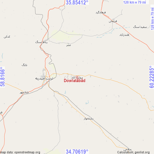
Dowlatābād GPS coordinates[2]
35° 16' 55.884" North, 59° 31' 10.992" East
| Map corner | latitude | longitude |
|---|---|---|
| Upper-left | 35.85412°, | 58.8166° |
| Center: | 35.28219°, | 59.51972° |
| Lower-right: | 34.70619°, | 60.22285° |
| Map W x H: | 127.6×127.6 km | = 79.3×79.3mi |
| max Lat: | 39.6482° ⇑40.1% North |
| Dowlatābād: | 35.28219° |
| min Lat: | ⇓59.9% South 25.2919° |
| min Long | Dowlatābād | max Long |
| 44.38416° | 59.51972° | 61.9965° |
| W 93.7%⇐ | ⇒6.3% E |
Elevation
Elevation of Dowlatābād is 1369 m = 4491 ft, and this is 320 m = 1050 ft above average elevation for this country.
| Max E: |
2564 m = 8412 ft | 36.7% |
| Dowlatābād | 1369 m 4491 ft | |
| Avg. | 1049 m = 3442 ft | |
Min E: |
-24 m = -79 ft | 63.3% |
See also: Iran elevation on elevation.city.
Geographical zone
Dowlatābād is located in North temperate zone (between Tropic of Cancer and the Arctic Circle). Distance of this Northern Tropic circle is 1317.1 km =818.4 mi to South.| Distance of | km | miles | from Dowlatābād |
|---|---|---|---|
| North Pole | 6084.1 | 3780.5 | to North |
| Arctic Circle | 3478.2 | 2161.3 | to North |
| Tropic Cancer | 1317.1 | 818.4 | to South |
| Equator | 3923 | 2437.6 | to South |


Nearby cities:
15 places around Dowlatābād: (largest is in red/bold)
• Bozghān
139.9 km =86.9 mi,  322°
322°
• Farīmān
55.9 km =34.7 mi,  32°
32°
• Feyẕābād
73.1 km =45.4 mi,  246°
246°
• Gonābād
128.5 km =79.8 mi,  216°
216°
• Khalīlābād
112.1 km =69.7 mi,  268°
268°
• Khvāf
96.8 km =60.1 mi,  144°
144°
• Kāshmar
95.8 km =59.5 mi, 267°
• Mashhad
115 km =71.5 mi,  2°
2°
• Neyshābūr
122.4 km =76.1 mi,  327°
327°
• Roshtkhvār
35.5 km =22.1 mi,  164°
164°
• Shahrak-e Bākharz
79.4 km =49.3 mi,  113°
113°
• Torbat-e Jām
100.2 km =62.3 mi,  92°
92°
• Torbat-e Ḩeydarīyeh
27.3 km =17 mi, 268°
• Tāybād
129.3 km =80.3 mi,  117°
117°
• Ţorqabeh
115.1 km =71.5 mi,  353°
353°
Sources, notices
• [Note1] Compared only with cities in Iran existing in our database
• [Src1] Map data: © OpenStreetMap contributors (CC-BY-SA)
• [Src2] Other city data from geonames.org with taken over terms of usage.
• [Src3] Geographical zone / Annual Mean Temperature by Robert A. Rohde @ Wikipedia
