Mīāneh geodata
Mīāneh (East Azerbaijan) is a seat of a second-order administrative division; located in Iran in Asia/Tehran (GMT+3.5) time zone. In our database, there are 232 cities with bigger population. Compared to other cities in Iran, 90.2% of cities are located further ↓South; 83.4% of cities are located further →East and 53.3% of cities have higher elevation than Mīāneh. Note1


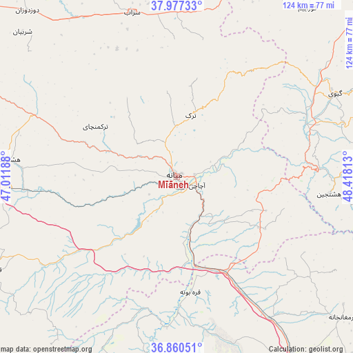
Mīāneh GPS coordinates[2]
37° 25' 15.6" North, 47° 42' 54" East
| Map corner | latitude | longitude |
|---|---|---|
| Upper-left | 37.97733°, | 47.01188° |
| Center: | 37.421°, | 47.715° |
| Lower-right: | 36.86051°, | 48.41813° |
| Map W x H: | 124.2×124.2 km | = 77.2×77.2mi |
| max Lat: | 39.6482° ⇑9.8% North |
| Mīāneh: | 37.421° |
| min Lat: | ⇓90.2% South 25.2919° |
| min Long | Mīāneh | max Long |
| 44.38416° | 47.715° | 61.9965° |
| W 16.6%⇐ | ⇒83.4% E |
Elevation
Elevation of Mīāneh is 1097 m = 3599 ft, and this is 48 m = 157 ft above average elevation for this country.
| Max E: |
2564 m = 8412 ft | 53.3% |
| Mīāneh | 1097 m 3599 ft | |
| Avg. | 1049 m = 3442 ft | |
Min E: |
-24 m = -79 ft | 46.7% |
See also: Iran elevation on elevation.city.
Geographical zone
Mīāneh is located in North temperate zone (between Tropic of Cancer and the Arctic Circle). Distance of this Northern Tropic circle is 1554.9 km =966.2 mi to South.| Distance of | km | miles | from Mīāneh |
|---|---|---|---|
| North Pole | 5846.2 | 3632.7 | to North |
| Arctic Circle | 3240.3 | 2013.4 | to North |
| Tropic Cancer | 1554.9 | 966.2 | to South |
| Equator | 4160.8 | 2585.4 | to South |


Nearby cities:
15 places around Mīāneh: (largest is in red/bold)
• Ardabīl
105.2 km =65.4 mi,  28°
28°
• Bostānābād
90.7 km =56.4 mi,  301°
301°
• Gīvī
62.6 km =38.9 mi,  61°
61°
• Hashtpar
112.8 km =70.1 mi,  68°
68°
• Hashtrūd
59 km =36.7 mi,  276°
276°
• Herīs
105.9 km =65.8 mi,  330°
330°
• Khalkhāl
75.1 km =46.7 mi, 73°
• Meshgīn Shahr
108.8 km =67.6 mi,  358°
358°
• Māhneshān
75.3 km =46.8 mi,  182°
182°
• Māsūleh
116.6 km =72.5 mi,  104°
104°
• Nīr
72.6 km =45.1 mi,  20°
20°
• Omīdcheh
103.3 km =64.2 mi, 21°
• Qarah Āghāj
49.5 km =30.8 mi,  242°
242°
• Sarāb
59.9 km =37.2 mi,  344°
344°
• Zanjān
108 km =67.1 mi,  140°
140°
Sources, notices
• [Note1] Compared only with cities in Iran existing in our database
• [Src1] Map data: © OpenStreetMap contributors (CC-BY-SA)
• [Src2] Other city data from geonames.org with taken over terms of usage.
• [Src3] Geographical zone / Annual Mean Temperature by Robert A. Rohde @ Wikipedia
