Kaleybar geodata
Kaleybar (East Azerbaijan) is a seat of a second-order administrative division; located in Iran in Asia/Tehran (GMT+3.5) time zone. In our database, there are 232 cities with bigger population. Compared to other cities in Iran, 98% of cities are located further ↓South; 88.2% of cities are located further →East and 51.9% of cities have higher elevation than Kaleybar. Note1


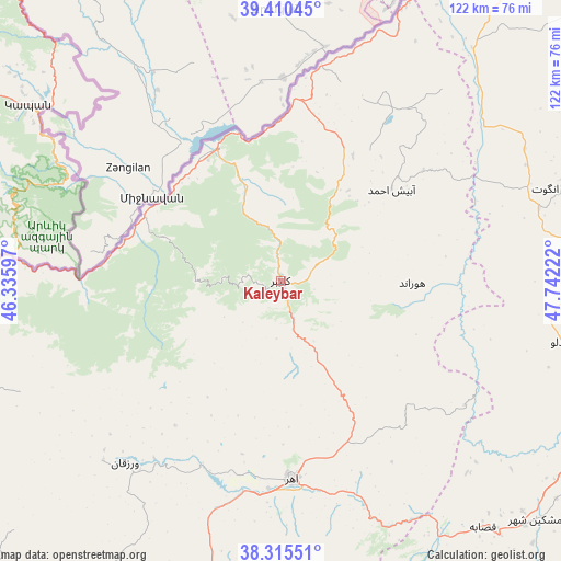
Kaleybar GPS coordinates[2]
38° 51' 54.324" North, 47° 2' 20.724" East
| Map corner | latitude | longitude |
|---|---|---|
| Upper-left | 39.41045°, | 46.33597° |
| Center: | 38.86509°, | 47.03909° |
| Lower-right: | 38.31551°, | 47.74222° |
| Map W x H: | 121.7×121.7 km | = 75.6×75.6mi |
| max Lat: | 39.6482° ⇑2% North |
| Kaleybar: | 38.86509° |
| min Lat: | ⇓98% South 25.2919° |
| min Long | Kaleybar | max Long |
| 44.38416° | 47.03909° | 61.9965° |
| W 11.8%⇐ | ⇒88.2% E |
Elevation
Elevation of Kaleybar is 1148 m = 3766 ft, and this is 99 m = 325 ft above average elevation for this country.
| Max E: |
2564 m = 8412 ft | 51.9% |
| Kaleybar | 1148 m 3766 ft | |
| Avg. | 1049 m = 3442 ft | |
Min E: |
-24 m = -79 ft | 48.1% |
See also: Iran elevation on elevation.city.
Geographical zone
Kaleybar is located in North temperate zone (between Tropic of Cancer and the Arctic Circle). Distance of this Northern Tropic circle is 1715.5 km =1066 mi to South.| Distance of | km | miles | from Kaleybar |
|---|---|---|---|
| North Pole | 5685.7 | 3532.9 | to North |
| Arctic Circle | 3079.8 | 1913.7 | to North |
| Tropic Cancer | 1715.5 | 1066 | to South |
| Equator | 4321.4 | 2685.2 | to South |


Nearby cities:
15 places around Kaleybar: (largest is in red/bold)
• Ahar
43.2 km =26.8 mi,  176°
176°
• Bostānābād
114.7 km =71.3 mi,  188°
188°
• Bīleh Savār
127.1 km =79 mi,  63°
63°
• Germī
91.7 km =57 mi,  79°
79°
• Herīs
68.9 km =42.8 mi,  174°
174°
• Khomārlū
31.6 km =19.6 mi,  359°
359°
• Marand
119.8 km =74.4 mi,  246°
246°
• Meshgīn Shahr
76.2 km =47.3 mi,  132°
132°
• Mīāb
108.8 km =67.6 mi,  260°
260°
• Nīr
124.5 km =77.4 mi,  137°
137°
• Omīdcheh
115.4 km =71.7 mi,  123°
123°
• Pārsābād
115.3 km =71.6 mi,  40°
40°
• Sarāb
111.5 km =69.3 mi,  157°
157°
• Tabriz
108.9 km =67.7 mi,  216°
216°
• Varazqān
83.1 km =51.6 mi, 255°
Sources, notices
• [Note1] Compared only with cities in Iran existing in our database
• [Src1] Map data: © OpenStreetMap contributors (CC-BY-SA)
• [Src2] Other city data from geonames.org with taken over terms of usage.
• [Src3] Geographical zone / Annual Mean Temperature by Robert A. Rohde @ Wikipedia
