Hendījān geodata
Hendījān (Khuzestan) is a seat of a second-order administrative division; located in Iran in Asia/Tehran (GMT+3.5) time zone. In our database, there are 232 cities with bigger population. Compared to other cities in Iran, 81.9% of cities are located further ↑North; 64.2% of cities are located further →East and 92.3% of cities have higher elevation than Hendījān. Note1


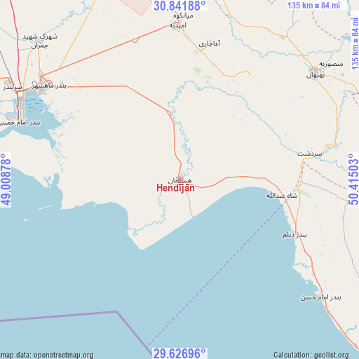
Hendījān GPS coordinates[2]
30° 14' 10.68" North, 49° 42' 42.84" East
| Map corner | latitude | longitude |
|---|---|---|
| Upper-left | 30.84188°, | 49.00878° |
| Center: | 30.2363°, | 49.7119° |
| Lower-right: | 29.62696°, | 50.41503° |
| Map W x H: | 135.1×135.1 km | = 83.9×83.9mi |
| max Lat: | 39.6482° ⇑81.9% North |
| Hendījān: | 30.2363° |
| min Lat: | ⇓18.1% South 25.2919° |
| min Long | Hendījān | max Long |
| 44.38416° | 49.7119° | 61.9965° |
| W 35.8%⇐ | ⇒64.2% E |
Elevation
Elevation of Hendījān is 9 m = 30 ft, and this is 1040 m = 3412 ft below average elevation for this country.
| Max E: |
2564 m = 8412 ft | 92.3% |
| Avg. | 1049 m = 3442 ft | |
| Hendījān | 9 m = 30 ft | |
Min E: |
-24 m = -79 ft | 7.7% |
See also: Iran elevation on elevation.city.
Geographical zone
Hendījān is located in North temperate zone (between Tropic of Cancer and the Arctic Circle). Distance of this Northern Tropic circle is 756 km =469.8 mi to South.| Distance of | km | miles | from Hendījān |
|---|---|---|---|
| North Pole | 6645.1 | 4129.1 | to North |
| Arctic Circle | 4039.2 | 2509.8 | to North |
| Tropic Cancer | 756 | 469.8 | to South |
| Equator | 3362 | 2089 | to South |


Nearby cities:
15 places around Hendījān: (largest is in red/bold)
• Abadan
135.6 km =84.3 mi,  274°
274°
• Aghajari
52.9 km =32.9 mi,  12°
12°
• Bandar-e Deylam
47.5 km =29.5 mi,  115°
115°
• Bandar-e Emam Khomeyni
62.6 km =38.9 mi,  290°
290°
• Bandar-e Genāveh
106.6 km =66.2 mi,  133°
133°
• Bandar-e Māhshahr
61.5 km =38.2 mi,  305°
305°
• Behbahān
64.6 km =40.1 mi,  51°
51°
• Dehdasht
102.6 km =63.8 mi, 52°
• Dogonbadan
105.2 km =65.4 mi,  82°
82°
• Khārk
123.8 km =76.9 mi,  151°
151°
• Līkak
81.8 km =50.8 mi,  26°
26°
• Omīdīyeh
58.5 km =36.4 mi,  359°
359°
• Rāmhormoz
116.5 km =72.4 mi,  354°
354°
• Rāmshīr
78.6 km =48.8 mi,  338°
338°
• Shādegān
110.4 km =68.6 mi, 294°
Sources, notices
• [Note1] Compared only with cities in Iran existing in our database
• [Src1] Map data: © OpenStreetMap contributors (CC-BY-SA)
• [Src2] Other city data from geonames.org with taken over terms of usage.
• [Src3] Geographical zone / Annual Mean Temperature by Robert A. Rohde @ Wikipedia
