Rāmhormoz geodata
Rāmhormoz (Khuzestan) is a seat of a second-order administrative division; located in Iran in Asia/Tehran (GMT+3.5) time zone. With population of 38,821 people, there are 155 cities with bigger population in this country. Compared to other cities in Iran, 74.4% of cities are located further ↑North; 65.5% of cities are located further →East and 79.6% of cities have higher elevation than Rāmhormoz. Note1


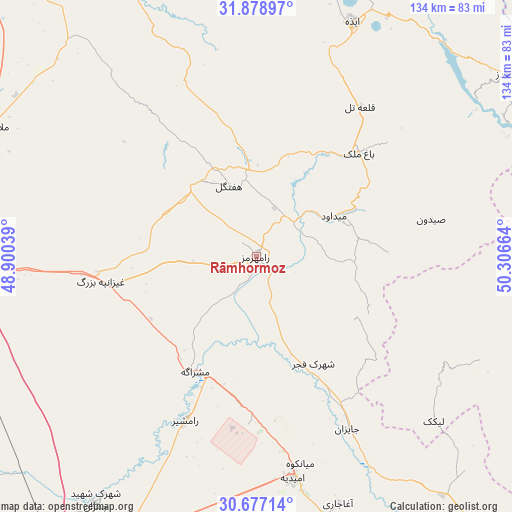
Rāmhormoz GPS coordinates[2]
31° 16' 47.892" North, 49° 36' 12.636" East
| Map corner | latitude | longitude |
|---|---|---|
| Upper-left | 31.87897°, | 48.90039° |
| Center: | 31.27997°, | 49.60351° |
| Lower-right: | 30.67714°, | 50.30664° |
| Map W x H: | 133.6×133.6 km | = 83×83mi |
| max Lat: | 39.6482° ⇑74.4% North |
| Rāmhormoz: | 31.27997° |
| min Lat: | ⇓25.6% South 25.2919° |
| min Long | Rāmhormoz | max Long |
| 44.38416° | 49.60351° | 61.9965° |
| W 34.5%⇐ | ⇒65.5% E |
Elevation
Elevation of Rāmhormoz is 160 m = 525 ft, and this is 889 m = 2917 ft below average elevation for this country.
| Max E: |
2564 m = 8412 ft | 79.6% |
| Avg. | 1049 m = 3442 ft | |
| Rāmhormoz | 160 m = 525 ft | |
Min E: |
-24 m = -79 ft | 20.4% |
See also: Iran elevation on elevation.city.
Geographical zone
Rāmhormoz is located in North temperate zone (between Tropic of Cancer and the Arctic Circle). Distance of this Northern Tropic circle is 872.1 km =541.9 mi to South.| Distance of | km | miles | from Rāmhormoz |
|---|---|---|---|
| North Pole | 6529.1 | 4057 | to North |
| Arctic Circle | 3923.2 | 2437.8 | to North |
| Tropic Cancer | 872.1 | 541.9 | to South |
| Equator | 3478 | 2161.1 | to South |


Nearby cities:
15 places around Rāmhormoz: (largest is in red/bold)
• Aghajari
68 km =42.3 mi,  161°
161°
• Ahvaz
87.4 km =54.3 mi,  272°
272°
• Bandar-e Emam Khomeyni
105.2 km =65.4 mi,  207°
207°
• Bandar-e Māhshahr
89.6 km =55.7 mi, 206°
• Behbahān
97.4 km =60.5 mi,  141°
141°
• Bāgh-e Malek
38.1 km =23.7 mi,  44°
44°
• Haftkel
19.8 km =12.3 mi,  339°
339°
• Jongīyeh
93.8 km =58.3 mi, 268°
• Līkak
63.3 km =39.3 mi,  132°
132°
• Masjed Soleymān
78.3 km =48.7 mi, 338°
• Mollās̄ānī
76 km =47.2 mi,  296°
296°
• Omīdīyeh
58.3 km =36.2 mi,  170°
170°
• Qal‘eh-ye Khvājeh
104.1 km =64.7 mi,  351°
351°
• Rāmshīr
46.9 km =29.1 mi,  203°
203°
• sedeyen-e Yek
75.1 km =46.7 mi,  276°
276°
Sources, notices
• [Note1] Compared only with cities in Iran existing in our database
• [Src1] Map data: © OpenStreetMap contributors (CC-BY-SA)
• [Src2] Other city data from geonames.org with taken over terms of usage.
• [Src3] Geographical zone / Annual Mean Temperature by Robert A. Rohde @ Wikipedia
