Abadan geodata
Abadan (Khuzestan) is a populated place; located in Iran in Asia/Tehran (GMT+3.5) time zone. With population of 370,180 people, there are 20 cities with bigger population in this country. Compared to other cities in Iran, 81% of cities are located further ↑North; 79.1% of cities are located further →East and 93.9% of cities have higher elevation than Abadan. Note1


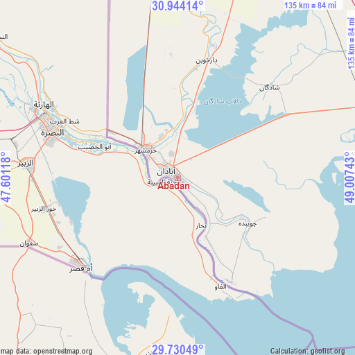
Abadan GPS coordinates[2]
30° 20' 21.12" North, 48° 18' 15.48" East
| Map corner | latitude | longitude |
|---|---|---|
| Upper-left | 30.94414°, | 47.60118° |
| Center: | 30.3392°, | 48.3043° |
| Lower-right: | 29.73049°, | 49.00743° |
| Map W x H: | 134.9×134.9 km | = 83.8×83.8mi |
| max Lat: | 39.6482° ⇑81% North |
| Abadan: | 30.3392° |
| min Lat: | ⇓19% South 25.2919° |
| min Long | Abadan | max Long |
| 44.38416° | 48.3043° | 61.9965° |
| W 20.9%⇐ | ⇒79.1% E |
Elevation
Elevation of Abadan is 6 m = 20 ft, and this is 1043 m = 3422 ft below average elevation for this country.
| Max E: |
2564 m = 8412 ft | 93.9% |
| Avg. | 1049 m = 3442 ft | |
| Abadan | 6 m = 20 ft | |
Min E: |
-24 m = -79 ft | 6.1% |
See also: Abadan elevation on elevation.city.
Geographical zone
Abadan is located in North temperate zone (between Tropic of Cancer and the Arctic Circle). Distance of this Northern Tropic circle is 767.5 km =476.9 mi to South.| Distance of | km | miles | from Abadan |
|---|---|---|---|
| North Pole | 6633.7 | 4122 | to North |
| Arctic Circle | 4027.8 | 2502.8 | to North |
| Tropic Cancer | 767.5 | 476.9 | to South |
| Equator | 3373.4 | 2096.1 | to South |


Nearby cities:
15 places around Abadan: (largest is in red/bold)
• Aghajari
151.7 km =94.3 mi,  74°
74°
• Ahvaz
114.8 km =71.3 mi,  18°
18°
• Bandar-e Emam Khomeyni
77.4 km =48.1 mi,  81°
81°
• Bandar-e Māhshahr
88.1 km =54.7 mi, 74°
• Hendījān
135.6 km =84.3 mi,  94°
94°
• Hoveyzeh
126.8 km =78.8 mi,  350°
350°
• Jongīyeh
106.2 km =66 mi, 16°
• Khorramshahr
16.1 km =10 mi,  314°
314°
• Mollās̄ānī
149.2 km =92.7 mi, 21°
• Omīdīyeh
141.9 km =88.2 mi, 70°
• Rāmhormoz
162.3 km =100.8 mi,  49°
49°
• Rāmshīr
122.2 km =75.9 mi,  59°
59°
• Shādegān
48.8 km =30.3 mi, 45°
• Sūsangerd
136.6 km =84.9 mi,  355°
355°
• sedeyen-e Yek
123.9 km =77 mi, 23°
Sources, notices
• [Note1] Compared only with cities in Iran existing in our database
• [Src1] Map data: © OpenStreetMap contributors (CC-BY-SA)
• [Src2] Other city data from geonames.org with taken over terms of usage.
• [Src3] Geographical zone / Annual Mean Temperature by Robert A. Rohde @ Wikipedia
