Khārk geodata
Khārk (Bushehr) is a populated place; located in Iran in Asia/Tehran (GMT+3.5) time zone. With population of 8,196 people, there are 208 cities with bigger population in this country. Compared to other cities in Iran, 86.6% of cities are located further ↑North; 59.2% of cities are located further →East and 92.3% of cities have higher elevation than Khārk. Note1


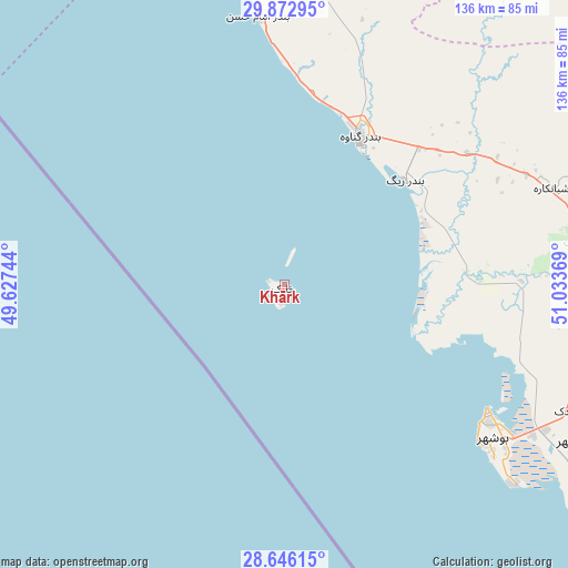
Khārk GPS coordinates[2]
29° 15' 41.004" North, 50° 19' 50.016" East
| Map corner | latitude | longitude |
|---|---|---|
| Upper-left | 29.87295°, | 49.62744° |
| Center: | 29.26139°, | 50.33056° |
| Lower-right: | 28.64615°, | 51.03369° |
| Map W x H: | 136.4×136.4 km | = 84.8×84.8mi |
| max Lat: | 39.6482° ⇑86.6% North |
| Khārk: | 29.26139° |
| min Lat: | ⇓13.4% South 25.2919° |
| min Long | Khārk | max Long |
| 44.38416° | 50.33056° | 61.9965° |
| W 40.8%⇐ | ⇒59.2% E |
Elevation
Elevation of Khārk is 9 m = 30 ft, and this is 1040 m = 3412 ft below average elevation for this country.
| Max E: |
2564 m = 8412 ft | 92.3% |
| Avg. | 1049 m = 3442 ft | |
| Khārk | 9 m = 30 ft | |
Min E: |
-24 m = -79 ft | 7.7% |
See also: Iran elevation on elevation.city.
Geographical zone
Khārk is located in North temperate zone (between Tropic of Cancer and the Arctic Circle). Distance of this Northern Tropic circle is 647.6 km =402.4 mi to South.| Distance of | km | miles | from Khārk |
|---|---|---|---|
| North Pole | 6753.5 | 4196.4 | to North |
| Arctic Circle | 4147.6 | 2577.2 | to North |
| Tropic Cancer | 647.6 | 402.4 | to South |
| Equator | 3253.6 | 2021.7 | to South |


Nearby cities:
15 places around Khārk: (largest is in red/bold)
• Aghajari
167.1 km =103.8 mi,  343°
343°
• Ahram
100.9 km =62.7 mi,  114°
114°
• Bandar-e Deylam
89.7 km =55.7 mi,  349°
349°
• Bandar-e Genāveh
39.7 km =24.7 mi,  27°
27°
• Behbahān
148.6 km =92.3 mi,  356°
356°
• Borāzjān
86.2 km =53.6 mi,  89°
89°
• Bushehr
58.9 km =36.6 mi,  123°
123°
• Bāsht
146 km =90.7 mi, 33°
• Dehdasht
172 km =106.9 mi,  7°
7°
• Dogonbadan
130.1 km =80.8 mi,  20°
20°
• Hendījān
123.8 km =76.9 mi,  331°
331°
• Khowrmūj
122.4 km =76.1 mi, 123°
• Kāzerūn
134.1 km =83.3 mi,  72°
72°
• Maşīrī
158.8 km =98.7 mi,  46°
46°
• Nūrābād
149.1 km =92.6 mi, 50°
Sources, notices
• [Note1] Compared only with cities in Iran existing in our database
• [Src1] Map data: © OpenStreetMap contributors (CC-BY-SA)
• [Src2] Other city data from geonames.org with taken over terms of usage.
• [Src3] Geographical zone / Annual Mean Temperature by Robert A. Rohde @ Wikipedia
