Dogonbadan geodata
Dogonbadan (Kohgiluyeh and Boyer-Ahmad) is a populated place; located in Iran in Asia/Tehran (GMT+3.5) time zone. With population of 94,638 people, there are 72 cities with bigger population in this country. Compared to other cities in Iran, 80.7% of cities are located further ↑North; 55.1% of cities are located further →East and 68.7% of cities have higher elevation than Dogonbadan. Note1


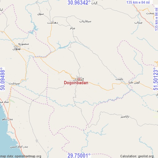
Dogonbadan GPS coordinates[2]
30° 21' 30.96" North, 50° 47' 53.16" East
| Map corner | latitude | longitude |
|---|---|---|
| Upper-left | 30.96342°, | 50.09498° |
| Center: | 30.3586°, | 50.7981° |
| Lower-right: | 29.75001°, | 51.50123° |
| Map W x H: | 134.9×134.9 km | = 83.8×83.8mi |
| max Lat: | 39.6482° ⇑80.7% North |
| Dogonbadan: | 30.3586° |
| min Lat: | ⇓19.3% South 25.2919° |
| min Long | Dogonbadan | max Long |
| 44.38416° | 50.7981° | 61.9965° |
| W 44.9%⇐ | ⇒55.1% E |
Elevation
Elevation of Dogonbadan is 723 m = 2372 ft, and this is 326 m = 1070 ft below average elevation for this country.
| Max E: |
2564 m = 8412 ft | 68.7% |
| Avg. | 1049 m = 3442 ft | |
| Dogonbadan | 723 m = 2372 ft | |
Min E: |
-24 m = -79 ft | 31.3% |
See also: Dogonbadan elevation on elevation.city.
Geographical zone
Dogonbadan is located in North temperate zone (between Tropic of Cancer and the Arctic Circle). Distance of this Northern Tropic circle is 769.6 km =478.2 mi to South.| Distance of | km | miles | from Dogonbadan |
|---|---|---|---|
| North Pole | 6631.5 | 4120.6 | to North |
| Arctic Circle | 4025.6 | 2501.4 | to North |
| Tropic Cancer | 769.6 | 478.2 | to South |
| Equator | 3375.6 | 2097.5 | to South |


Nearby cities:
15 places around Dogonbadan: (largest is in red/bold)
• Aghajari
100.1 km =62.2 mi,  292°
292°
• Bandar-e Deylam
70.1 km =43.6 mi,  241°
241°
• Bandar-e Genāveh
90.8 km =56.4 mi,  197°
197°
• Behbahān
59.5 km =37 mi,  296°
296°
• Bāsht
34.5 km =21.4 mi,  89°
89°
• Dehdasht
53.4 km =33.2 mi,  335°
335°
• Hendījān
105.2 km =65.4 mi,  262°
262°
• Kāzerūn
116.4 km =72.3 mi,  134°
134°
• Līkak
90 km =55.9 mi,  311°
311°
• Maşīrī
70.6 km =43.9 mi,  100°
100°
• Nūrābād
74.6 km =46.4 mi,  111°
111°
• Omīdīyeh
114.1 km =70.9 mi, 293°
• Sepīdān
114.4 km =71.1 mi, 95°
• Sīsakht
84.4 km =52.4 mi,  48°
48°
• Yasuj
83.1 km =51.6 mi,  65°
65°
Sources, notices
• [Note1] Compared only with cities in Iran existing in our database
• [Src1] Map data: © OpenStreetMap contributors (CC-BY-SA)
• [Src2] Other city data from geonames.org with taken over terms of usage.
• [Src3] Geographical zone / Annual Mean Temperature by Robert A. Rohde @ Wikipedia
