Shādegān geodata
Shādegān (Khuzestan) is a seat of a second-order administrative division; located in Iran in Asia/Tehran (GMT+3.5) time zone. With population of 37,220 people, there are 161 cities with bigger population in this country. Compared to other cities in Iran, 78.7% of cities are located further ↑North; 74.6% of cities are located further →East and 91.4% of cities have higher elevation than Shādegān. Note1


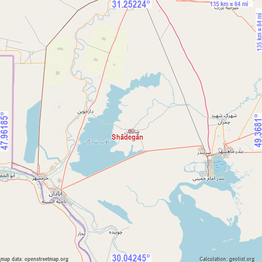
Shādegān GPS coordinates[2]
30° 38' 57.264" North, 48° 39' 53.892" East
| Map corner | latitude | longitude |
|---|---|---|
| Upper-left | 31.25224°, | 47.96185° |
| Center: | 30.64924°, | 48.66497° |
| Lower-right: | 30.04245°, | 49.3681° |
| Map W x H: | 134.5×134.5 km | = 83.6×83.6mi |
| max Lat: | 39.6482° ⇑78.7% North |
| Shādegān: | 30.64924° |
| min Lat: | ⇓21.3% South 25.2919° |
| min Long | Shādegān | max Long |
| 44.38416° | 48.66497° | 61.9965° |
| W 25.4%⇐ | ⇒74.6% E |
Elevation
Elevation of Shādegān is 10 m = 33 ft, and this is 1039 m = 3409 ft below average elevation for this country.
| Max E: |
2564 m = 8412 ft | 91.4% |
| Avg. | 1049 m = 3442 ft | |
| Shādegān | 10 m = 33 ft | |
Min E: |
-24 m = -79 ft | 8.6% |
See also: Iran elevation on elevation.city.
Geographical zone
Shādegān is located in North temperate zone (between Tropic of Cancer and the Arctic Circle). Distance of this Northern Tropic circle is 802 km =498.3 mi to South.| Distance of | km | miles | from Shādegān |
|---|---|---|---|
| North Pole | 6599.2 | 4100.6 | to North |
| Arctic Circle | 3993.3 | 2481.3 | to North |
| Tropic Cancer | 802 | 498.3 | to South |
| Equator | 3407.9 | 2117.6 | to South |


Nearby cities:
15 places around Shādegān: (largest is in red/bold)
• Abadan
48.8 km =30.3 mi,  225°
225°
• Aghajari
111.7 km =69.4 mi,  87°
87°
• Ahvaz
74.5 km =46.3 mi,  1°
1°
• Bandar-e Emam Khomeyni
48.1 km =29.9 mi,  119°
119°
• Bandar-e Māhshahr
51.2 km =31.8 mi,  101°
101°
• Hendījān
110.4 km =68.6 mi,  114°
114°
• Hoveyzeh
106.5 km =66.2 mi,  328°
328°
• Jongīyeh
67.6 km =42 mi,  356°
356°
• Khorramshahr
51.5 km =32 mi,  243°
243°
• Mollās̄ānī
106.1 km =65.9 mi,  11°
11°
• Omīdīyeh
100 km =62.1 mi,  82°
82°
• Rāmhormoz
113.7 km =70.6 mi,  51°
51°
• Rāmshīr
76 km =47.2 mi,  69°
69°
• Sūsangerd
111.3 km =69.2 mi,  336°
336°
• sedeyen-e Yek
80.6 km =50.1 mi, 10°
Sources, notices
• [Note1] Compared only with cities in Iran existing in our database
• [Src1] Map data: © OpenStreetMap contributors (CC-BY-SA)
• [Src2] Other city data from geonames.org with taken over terms of usage.
• [Src3] Geographical zone / Annual Mean Temperature by Robert A. Rohde @ Wikipedia
