Shahrak-e Kūlūrī geodata
Shahrak-e Kūlūrī (Khuzestan) is a populated place; located in Iran in Asia/Tehran (GMT+3.5) time zone. With population of 1,941 people, there are 221 cities with bigger population in this country. Compared to other cities in Iran, 66.4% of cities are located further ↑North; 76.6% of cities are located further →East and 81.4% of cities have higher elevation than Shahrak-e Kūlūrī. Note1


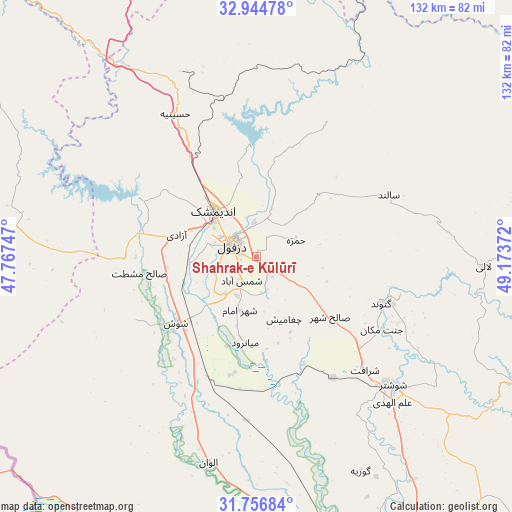
Shahrak-e Kūlūrī GPS coordinates[2]
32° 21' 9.936" North, 48° 28' 14.124" East
| Map corner | latitude | longitude |
|---|---|---|
| Upper-left | 32.94478°, | 47.76747° |
| Center: | 32.35276°, | 48.47059° |
| Lower-right: | 31.75684°, | 49.17372° |
| Map W x H: | 132.1×132.1 km | = 82.1×82.1mi |
| max Lat: | 39.6482° ⇑66.4% North |
| Shahrak-e Kūlūrī: | 32.35276° |
| min Lat: | ⇓33.6% South 25.2919° |
| min Long | Shahrak-e Kūl� | max Long |
| 44.38416° | 48.47059° | 61.9965° |
| W 23.4%⇐ | ⇒76.6% E |
Elevation
Elevation of Shahrak-e Kūlūrī is 140 m = 459 ft, and this is 909 m = 2982 ft below average elevation for this country.
| Max E: |
2564 m = 8412 ft | 81.4% |
| Avg. | 1049 m = 3442 ft | |
| Shahrak-e Kūlūrī | 140 m = 459 ft | |
Min E: |
-24 m = -79 ft | 18.6% |
See also: Iran elevation on elevation.city.
Geographical zone
Shahrak-e Kūlūrī is located in North temperate zone (between Tropic of Cancer and the Arctic Circle). Distance of this Northern Tropic circle is 991.4 km =616 mi to South.| Distance of | km | miles | from Shahrak-e Kūlūrī |
|---|---|---|---|
| North Pole | 6409.8 | 3982.9 | to North |
| Arctic Circle | 3803.9 | 2363.6 | to North |
| Tropic Cancer | 991.4 | 616 | to South |
| Equator | 3597.3 | 2235.3 | to South |


Nearby cities:
15 places around Shahrak-e Kūlūrī: (largest is in red/bold)
• Ahvaz
116.7 km =72.5 mi,  170°
170°
• Andīmeshk
16.3 km =10.1 mi,  317°
317°
• Dasht-e Lati
58.5 km =36.4 mi,  92°
92°
• Dehlorān
119 km =73.9 mi,  288°
288°
• Dezful
6.9 km =4.3 mi,  297°
297°
• Hoveyzeh
105.9 km =65.8 mi,  200°
200°
• Masjed Soleymān
91.1 km =56.6 mi,  120°
120°
• Mollās̄ānī
94 km =58.4 mi,  155°
155°
• Poldokhtar
113.9 km =70.8 mi, 321°
• Qal‘eh-ye Khvājeh
93.1 km =57.8 mi,  100°
100°
• Shūsh
27.7 km =17.2 mi,  230°
230°
• Shūshtar
49 km =30.4 mi,  133°
133°
• Sūsangerd
91.7 km =57 mi, 196°
• sedeyen-e Yek
114.9 km =71.4 mi, 163°
• Ābdānān
121.4 km =75.4 mi,  305°
305°
Sources, notices
• [Note1] Compared only with cities in Iran existing in our database
• [Src1] Map data: © OpenStreetMap contributors (CC-BY-SA)
• [Src2] Other city data from geonames.org with taken over terms of usage.
• [Src3] Geographical zone / Annual Mean Temperature by Robert A. Rohde @ Wikipedia
