Dezful geodata
Dezful (Khuzestan) is a seat of a second-order administrative division; located in Iran in Asia/Tehran (GMT+3.5) time zone. In our database, there are 232 cities with bigger population. Compared to other cities in Iran, 66.2% of cities are located further ↑North; 77.8% of cities are located further →East and 81% of cities have higher elevation than Dezful. Note1


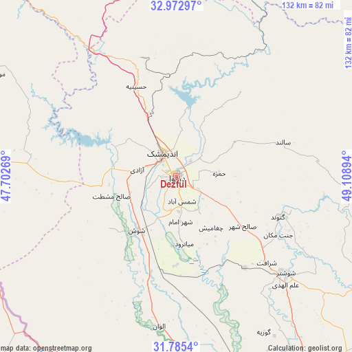
Dezful GPS coordinates[2]
32° 22' 52.104" North, 48° 24' 20.916" East
| Map corner | latitude | longitude |
|---|---|---|
| Upper-left | 32.97297°, | 47.70269° |
| Center: | 32.38114°, | 48.40581° |
| Lower-right: | 31.7854°, | 49.10894° |
| Map W x H: | 132×132 km | = 82×82mi |
| max Lat: | 39.6482° ⇑66.2% North |
| Dezful: | 32.38114° |
| min Lat: | ⇓33.8% South 25.2919° |
| min Long | Dezful | max Long |
| 44.38416° | 48.40581° | 61.9965° |
| W 22.2%⇐ | ⇒77.8% E |
Elevation
Elevation of Dezful is 143 m = 469 ft, and this is 906 m = 2972 ft below average elevation for this country.
| Max E: |
2564 m = 8412 ft | 81% |
| Avg. | 1049 m = 3442 ft | |
| Dezful | 143 m = 469 ft | |
Min E: |
-24 m = -79 ft | 19% |
See also: Iran elevation on elevation.city.
Geographical zone
Dezful is located in North temperate zone (between Tropic of Cancer and the Arctic Circle). Distance of this Northern Tropic circle is 994.5 km =618 mi to South.| Distance of | km | miles | from Dezful |
|---|---|---|---|
| North Pole | 6406.6 | 3980.9 | to North |
| Arctic Circle | 3800.7 | 2361.6 | to North |
| Tropic Cancer | 994.5 | 618 | to South |
| Equator | 3600.4 | 2237.2 | to South |


Nearby cities:
15 places around Dezful: (largest is in red/bold)
• Ahvaz
121 km =75.2 mi,  167°
167°
• Andīmeshk
10.2 km =6.3 mi,  331°
331°
• Dasht-e Lati
64.8 km =40.3 mi,  95°
95°
• Dehlorān
112.2 km =69.7 mi,  288°
288°
• Hoveyzeh
106.9 km =66.4 mi,  197°
197°
• Masjed Soleymān
97.9 km =60.8 mi,  120°
120°
• Mollās̄ānī
99.5 km =61.8 mi,  152°
152°
• Poldokhtar
107.6 km =66.9 mi,  322°
322°
• Qal‘eh-ye Khvājeh
99.6 km =61.9 mi, 101°
• Shahrak-e Kūlūrī
6.9 km =4.3 mi, 117°
• Shūsh
25.8 km =16 mi,  216°
216°
• Shūshtar
55.6 km =34.5 mi,  131°
131°
• Sūsangerd
93.2 km =57.9 mi,  192°
192°
• sedeyen-e Yek
119.8 km =74.4 mi,  161°
161°
• Ābdānān
114.6 km =71.2 mi,  306°
306°
Sources, notices
• [Note1] Compared only with cities in Iran existing in our database
• [Src1] Map data: © OpenStreetMap contributors (CC-BY-SA)
• [Src2] Other city data from geonames.org with taken over terms of usage.
• [Src3] Geographical zone / Annual Mean Temperature by Robert A. Rohde @ Wikipedia
