Shūsh geodata
Shūsh (Khuzestan) is a seat of a second-order administrative division; located in Iran in Asia/Tehran (GMT+3.5) time zone. With population of 52,284 people, there are 122 cities with bigger population in this country. Compared to other cities in Iran, 68.7% of cities are located further ↑North; 80% of cities are located further →East and 82.5% of cities have higher elevation than Shūsh. Note1


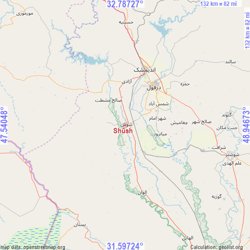
Shūsh GPS coordinates[2]
32° 11' 39.12" North, 48° 14' 36.96" East
| Map corner | latitude | longitude |
|---|---|---|
| Upper-left | 32.78727°, | 47.54048° |
| Center: | 32.1942°, | 48.2436° |
| Lower-right: | 31.59724°, | 48.94673° |
| Map W x H: | 132.3×132.3 km | = 82.2×82.2mi |
| max Lat: | 39.6482° ⇑68.7% North |
| Shūsh: | 32.1942° |
| min Lat: | ⇓31.3% South 25.2919° |
| min Long | Shūsh | max Long |
| 44.38416° | 48.2436° | 61.9965° |
| W 20%⇐ | ⇒80% E |
Elevation
Elevation of Shūsh is 71 m = 233 ft, and this is 978 m = 3209 ft below average elevation for this country.
| Max E: |
2564 m = 8412 ft | 82.5% |
| Avg. | 1049 m = 3442 ft | |
| Shūsh | 71 m = 233 ft | |
Min E: |
-24 m = -79 ft | 17.5% |
See also: Shūsh elevation on elevation.city.
Geographical zone
Shūsh is located in North temperate zone (between Tropic of Cancer and the Arctic Circle). Distance of this Northern Tropic circle is 973.7 km =605 mi to South.| Distance of | km | miles | from Shūsh |
|---|---|---|---|
| North Pole | 6427.4 | 3993.8 | to North |
| Arctic Circle | 3821.5 | 2374.6 | to North |
| Tropic Cancer | 973.7 | 605 | to South |
| Equator | 3579.7 | 2224.3 | to South |


Nearby cities:
15 places around Shūsh: (largest is in red/bold)
• Ahvaz
105.9 km =65.8 mi,  156°
156°
• Andīmeshk
31.5 km =19.6 mi,  19°
19°
• Dasht-e Lati
81.3 km =50.5 mi,  79°
79°
• Dehlorān
107.1 km =66.5 mi,  301°
301°
• Dezful
25.8 km =16 mi,  36°
36°
• Hoveyzeh
83 km =51.6 mi,  191°
191°
• Jongīyeh
110.1 km =68.4 mi, 161°
• Masjed Soleymān
103.9 km =64.6 mi,  106°
106°
• Mollās̄ānī
90.9 km =56.5 mi,  138°
138°
• Qal‘eh-ye Khvājeh
113.1 km =70.3 mi,  89°
89°
• Shahrak-e Kūlūrī
27.7 km =17.2 mi,  50°
50°
• Shūshtar
59.2 km =36.8 mi, 105°
• Sūsangerd
70.3 km =43.7 mi,  184°
184°
• sedeyen-e Yek
107.3 km =66.7 mi,  149°
149°
• Ābdānān
117.6 km =73.1 mi,  318°
318°
In other languages:
- In Spanish: Susa
- In France: Suse
- In German: Susa
- In Italian: Susa
- In Russian: Сузы
Sources, notices
• [Note1] Compared only with cities in Iran existing in our database
• [Src1] Map data: © OpenStreetMap contributors (CC-BY-SA)
• [Src2] Other city data from geonames.org with taken over terms of usage.
• [Src3] Geographical zone / Annual Mean Temperature by Robert A. Rohde @ Wikipedia
