‘Abbāsābād geodata
‘Abbāsābād (Māzandarān) is a seat of a second-order administrative division; located in Iran in Asia/Tehran (GMT+3.5) time zone. In our database, there are 232 cities with bigger population. Compared to other cities in Iran, 78.9% of cities are located further ↓South; 51.9% of cities are located further →East and 98.4% of cities have higher elevation than ‘Abbāsābād. Note1


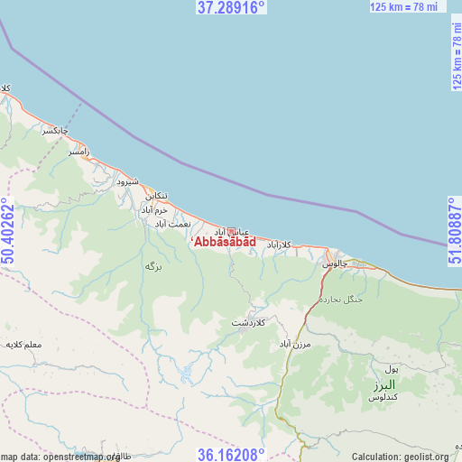
‘Abbāsābād GPS coordinates[2]
36° 43' 39.684" North, 51° 6' 20.664" East
| Map corner | latitude | longitude |
|---|---|---|
| Upper-left | 37.28916°, | 50.40262° |
| Center: | 36.72769°, | 51.10574° |
| Lower-right: | 36.16208°, | 51.80887° |
| Map W x H: | 125.3×125.3 km | = 77.9×77.9mi |
| max Lat: | 39.6482° ⇑21.1% North |
| ‘Abbāsābād: | 36.72769° |
| min Lat: | ⇓78.9% South 25.2919° |
| min Long | ‘Abbāsābād | max Long |
| 44.38416° | 51.10574° | 61.9965° |
| W 48.1%⇐ | ⇒51.9% E |
Elevation
Elevation of ‘Abbāsābād is -19 m = -62 ft, and this is 1068 m = 3504 ft below average elevation for this country.
| Max E: |
2564 m = 8412 ft | 98.4% |
| Avg. | 1049 m = 3442 ft | |
| ‘Abbāsābād | -19 m = -62 ft | |
Min E: |
-24 m = -79 ft | 1.6% |
See also: Iran elevation on elevation.city.
Geographical zone
‘Abbāsābād is located in North temperate zone (between Tropic of Cancer and the Arctic Circle). Distance of this Northern Tropic circle is 1477.8 km =918.3 mi to South.| Distance of | km | miles | from ‘Abbāsābād |
|---|---|---|---|
| North Pole | 5923.3 | 3680.6 | to North |
| Arctic Circle | 3317.4 | 2061.3 | to North |
| Tropic Cancer | 1477.8 | 918.3 | to South |
| Equator | 4083.7 | 2537.5 | to South |


Nearby cities:
15 places around ‘Abbāsābād: (largest is in red/bold)
• Amlash
91.4 km =56.8 mi,  296°
296°
• Chālūs
29.2 km =18.1 mi,  106°
106°
• Hashtgerd
93.3 km =58 mi,  204°
204°
• Karaj
100 km =62.1 mi,  185°
185°
• Langarūd
99.4 km =61.8 mi, 301°
• Nashtārūd
7.8 km =4.8 mi,  289°
289°
• Naz̧arābād
97 km =60.3 mi,  207°
207°
• Nowshahr
35.9 km =22.3 mi,  104°
104°
• Nūr
83 km =51.6 mi, 102°
• Rāmsar
45.9 km =28.5 mi, 297°
• Rūdsar
85.5 km =53.1 mi, 302°
• Shahrak
68.5 km =42.6 mi, 206°
• Tonekābon
22.9 km =14.2 mi, 295°
• Ābyek
88.7 km =55.1 mi, 214°
• Ābyek
92.2 km =57.3 mi, 213°
Sources, notices
• [Note1] Compared only with cities in Iran existing in our database
• [Src1] Map data: © OpenStreetMap contributors (CC-BY-SA)
• [Src2] Other city data from geonames.org with taken over terms of usage.
• [Src3] Geographical zone / Annual Mean Temperature by Robert A. Rohde @ Wikipedia
