Abarkūh geodata
Abarkūh (Yazd) is a seat of a second-order administrative division; located in Iran in Asia/Tehran (GMT+3.5) time zone. In our database, there are 232 cities with bigger population. Compared to other cities in Iran, 75.7% of cities are located further ↑North; 67.8% of cities are located further ←West and 70.3% of cities have lower elevation than Abarkūh. Note1


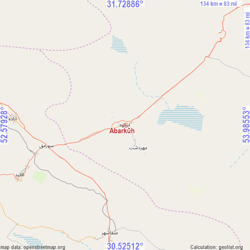
Abarkūh GPS coordinates[2]
31° 7' 44.04" North, 53° 16' 56.64" East
| Map corner | latitude | longitude |
|---|---|---|
| Upper-left | 31.72886°, | 52.57928° |
| Center: | 31.1289°, | 53.2824° |
| Lower-right: | 30.52512°, | 53.98553° |
| Map W x H: | 133.8×133.8 km | = 83.1×83.1mi |
| max Lat: | 39.6482° ⇑75.7% North |
| Abarkūh: | 31.1289° |
| min Lat: | ⇓24.3% South 25.2919° |
| min Long | Abarkūh | max Long |
| 44.38416° | 53.2824° | 61.9965° |
| W 67.8%⇐ | ⇒32.2% E |
Elevation
Elevation of Abarkūh is 1508 m = 4948 ft, and this is 459 m = 1506 ft above average elevation for this country.
| Max E: |
2564 m = 8412 ft | 29.7% |
| Abarkūh | 1508 m 4948 ft | |
| Avg. | 1049 m = 3442 ft | |
Min E: |
-24 m = -79 ft | 70.3% |
See also: Iran elevation on elevation.city.
Geographical zone
Abarkūh is located in North temperate zone (between Tropic of Cancer and the Arctic Circle). Distance of this Northern Tropic circle is 855.3 km =531.5 mi to South.| Distance of | km | miles | from Abarkūh |
|---|---|---|---|
| North Pole | 6545.9 | 4067.4 | to North |
| Arctic Circle | 3940 | 2448.2 | to North |
| Tropic Cancer | 855.3 | 531.5 | to South |
| Equator | 3461.2 | 2150.7 | to South |


Nearby cities:
15 places around Abarkūh: (largest is in red/bold)
• Ardakān
148.6 km =92.3 mi,  27°
27°
• Arsanjān
135.3 km =84.1 mi,  178°
178°
• Eqlīd
61.4 km =38.2 mi,  245°
245°
• Khavāş Kūh
136 km =84.5 mi,  15°
15°
• Mahrīz
121.3 km =75.4 mi,  65°
65°
• Marvdasht
146.9 km =91.3 mi,  198°
198°
• Meybod
142.7 km =88.7 mi, 29°
• Pāsārgād
103.5 km =64.3 mi,  185°
185°
• Sa‘ādat Shahr
117.6 km =73.1 mi, 186°
• Sūrīān
82.8 km =51.4 mi,  154°
154°
• Taft
110.9 km =68.9 mi,  51°
51°
• Taft
113.6 km =70.6 mi, 51°
• Yazd
133.7 km =83.1 mi, 50°
• Ābādeh
60.2 km =37.4 mi,  273°
273°
• Şafāshahr
57.9 km =36 mi, 188°
Sources, notices
• [Note1] Compared only with cities in Iran existing in our database
• [Src1] Map data: © OpenStreetMap contributors (CC-BY-SA)
• [Src2] Other city data from geonames.org with taken over terms of usage.
• [Src3] Geographical zone / Annual Mean Temperature by Robert A. Rohde @ Wikipedia
