Yazd geodata
Yazd is a seat of a first-order administrative division; located in Iran in Asia/Tehran (GMT+3.5) time zone. With population of 477,905 people, there are 18 cities with bigger population in this country. Compared to other cities in Iran, 70.5% of cities are located further ↑North; 74.1% of cities are located further ←West and 53.5% of cities have lower elevation than Yazd. Note1


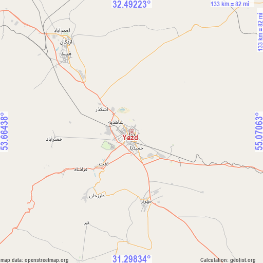
Yazd GPS coordinates[2]
31° 53' 49.992" North, 54° 22' 3" East
| Map corner | latitude | longitude |
|---|---|---|
| Upper-left | 32.49223°, | 53.66438° |
| Center: | 31.89722°, | 54.3675° |
| Lower-right: | 31.29834°, | 55.07063° |
| Map W x H: | 132.7×132.7 km | = 82.5×82.5mi |
| max Lat: | 39.6482° ⇑70.5% North |
| Yazd: | 31.89722° |
| min Lat: | ⇓29.5% South 25.2919° |
| min Long | Yazd | max Long |
| 44.38416° | 54.3675° | 61.9965° |
| W 74.1%⇐ | ⇒25.9% E |
Elevation
Elevation of Yazd is 1216 m = 3990 ft, and this is 167 m = 548 ft above average elevation for this country.
| Max E: |
2564 m = 8412 ft | 46.5% |
| Yazd | 1216 m 3990 ft | |
| Avg. | 1049 m = 3442 ft | |
Min E: |
-24 m = -79 ft | 53.5% |
See also: Yazd elevation on elevation.city.
Geographical zone
Yazd is located in North temperate zone (between Tropic of Cancer and the Arctic Circle). Distance of this Northern Tropic circle is 940.7 km =584.5 mi to South.| Distance of | km | miles | from Yazd |
|---|---|---|---|
| North Pole | 6460.4 | 4014.3 | to North |
| Arctic Circle | 3854.5 | 2395.1 | to North |
| Tropic Cancer | 940.7 | 584.5 | to South |
| Equator | 3546.6 | 2203.8 | to South |


Nearby cities:
15 places around Yazd: (largest is in red/bold)
• Abarkūh
133.7 km =83.1 mi,  230°
230°
• Anār
142.7 km =88.7 mi,  143°
143°
• Ardakān
56.5 km =35.1 mi,  324°
324°
• Bahābād
156.5 km =97.2 mi,  91°
91°
• Bāfq
103.2 km =64.1 mi,  108°
108°
• Khavāş Kūh
79.6 km =49.5 mi,  304°
304°
• Kūhbanān
189.2 km =117.6 mi, 106°
• Mahrīz
35.5 km =22.1 mi,  168°
168°
• Meybod
51.3 km =31.9 mi, 319°
• Nā’īn
161 km =100 mi,  311°
311°
• Sūrīān
174.2 km =108.2 mi,  203°
203°
• Taft
20.4 km =12.7 mi,  221°
221°
• Taft
23.1 km =14.4 mi, 222°
• Ābādeh
182.2 km =113.2 mi,  243°
243°
• Şafāshahr
181.1 km =112.5 mi, 217°
Sources, notices
• [Note1] Compared only with cities in Iran existing in our database
• [Src1] Map data: © OpenStreetMap contributors (CC-BY-SA)
• [Src2] Other city data from geonames.org with taken over terms of usage.
• [Src3] Geographical zone / Annual Mean Temperature by Robert A. Rohde @ Wikipedia
