Sūrīān geodata
Sūrīān (Fars) is a seat of a second-order administrative division; located in Iran in Asia/Tehran (GMT+3.5) time zone. In our database, there are 232 cities with bigger population. Compared to other cities in Iran, 79.6% of cities are located further ↑North; 70.1% of cities are located further ←West and 96.8% of cities have lower elevation than Sūrīān. Note1


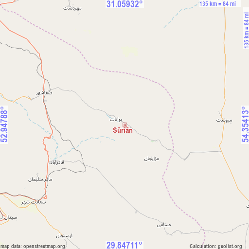
Sūrīān GPS coordinates[2]
30° 27' 18.36" North, 53° 39' 3.6" East
| Map corner | latitude | longitude |
|---|---|---|
| Upper-left | 31.05932°, | 52.94788° |
| Center: | 30.4551°, | 53.651° |
| Lower-right: | 29.84711°, | 54.35413° |
| Map W x H: | 134.8×134.8 km | = 83.8×83.8mi |
| max Lat: | 39.6482° ⇑79.6% North |
| Sūrīān: | 30.4551° |
| min Lat: | ⇓20.4% South 25.2919° |
| min Long | Sūrīān | max Long |
| 44.38416° | 53.651° | 61.9965° |
| W 70.1%⇐ | ⇒29.9% E |
Elevation
Elevation of Sūrīān is 2182 m = 7159 ft, and this is 1133 m = 3717 ft above average elevation for this country.
| Max E: |
2564 m = 8412 ft | 3.2% |
| Sūrīān | 2182 m 7159 ft | |
| Avg. | 1049 m = 3442 ft | |
Min E: |
-24 m = -79 ft | 96.8% |
See also: Iran elevation on elevation.city.
Geographical zone
Sūrīān is located in North temperate zone (between Tropic of Cancer and the Arctic Circle). Distance of this Northern Tropic circle is 780.4 km =484.9 mi to South.| Distance of | km | miles | from Sūrīān |
|---|---|---|---|
| North Pole | 6620.8 | 4114 | to North |
| Arctic Circle | 4014.9 | 2494.7 | to North |
| Tropic Cancer | 780.4 | 484.9 | to South |
| Equator | 3386.3 | 2104.1 | to South |


Nearby cities:
15 places around Sūrīān: (largest is in red/bold)
• Abarkūh
82.8 km =51.4 mi,  334°
334°
• Arsanjān
68.7 km =42.7 mi,  208°
208°
• Eqlīd
103.7 km =64.4 mi,  298°
298°
• Estahbān
152.5 km =94.8 mi,  165°
165°
• Kherāmeh
111.2 km =69.1 mi,  197°
197°
• Mahrīz
146.5 km =91 mi,  31°
31°
• Marvdasht
104 km =64.6 mi,  231°
231°
• Pāsārgād
53.3 km =33.1 mi,  238°
238°
• Sarvestān
137.8 km =85.6 mi, 197°
• Sa‘ādat Shahr
64.9 km =40.3 mi, 229°
• Shahr-e Bābak
145.9 km =90.7 mi,  104°
104°
• Shahr-e Herāt
82.4 km =51.2 mi,  122°
122°
• Shiraz
143 km =88.9 mi, 228°
• Ābādeh
123.6 km =76.8 mi,  309°
309°
• Şafāshahr
47 km =29.2 mi,  291°
291°
Sources, notices
• [Note1] Compared only with cities in Iran existing in our database
• [Src1] Map data: © OpenStreetMap contributors (CC-BY-SA)
• [Src2] Other city data from geonames.org with taken over terms of usage.
• [Src3] Geographical zone / Annual Mean Temperature by Robert A. Rohde @ Wikipedia
