Şafāshahr geodata
Şafāshahr (Fars) is a seat of a second-order administrative division; located in Iran in Asia/Tehran (GMT+3.5) time zone. In our database, there are 232 cities with bigger population. Compared to other cities in Iran, 78.9% of cities are located further ↑North; 66.9% of cities are located further ←West and 98.6% of cities have lower elevation than Şafāshahr. Note1


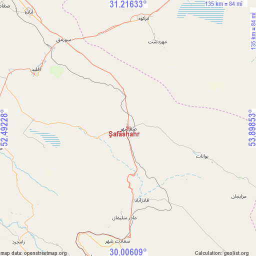
Şafāshahr GPS coordinates[2]
30° 36' 47.16" North, 53° 11' 43.44" East
| Map corner | latitude | longitude |
|---|---|---|
| Upper-left | 31.21633°, | 52.49228° |
| Center: | 30.6131°, | 53.1954° |
| Lower-right: | 30.00609°, | 53.89853° |
| Map W x H: | 134.6×134.6 km | = 83.6×83.6mi |
| max Lat: | 39.6482° ⇑78.9% North |
| Şafāshahr: | 30.6131° |
| min Lat: | ⇓21.1% South 25.2919° |
| min Long | Şafāshahr | max Long |
| 44.38416° | 53.1954° | 61.9965° |
| W 66.9%⇐ | ⇒33.1% E |
Elevation
Elevation of Şafāshahr is 2299 m = 7543 ft, and this is 1250 m = 4101 ft above average elevation for this country.
| Max E: |
2564 m = 8412 ft | 1.4% |
| Şafāshahr | 2299 m 7543 ft | |
| Avg. | 1049 m = 3442 ft | |
Min E: |
-24 m = -79 ft | 98.6% |
See also: Iran elevation on elevation.city.
Geographical zone
Şafāshahr is located in North temperate zone (between Tropic of Cancer and the Arctic Circle). Distance of this Northern Tropic circle is 797.9 km =495.8 mi to South.| Distance of | km | miles | from Şafāshahr |
|---|---|---|---|
| North Pole | 6603.2 | 4103 | to North |
| Arctic Circle | 3997.3 | 2483.8 | to North |
| Tropic Cancer | 797.9 | 495.8 | to South |
| Equator | 3403.9 | 2115.1 | to South |


Nearby cities:
15 places around Şafāshahr: (largest is in red/bold)
• Abarkūh
57.9 km =36 mi,  8°
8°
• Akbarābād
157.2 km =97.7 mi,  194°
194°
• Arsanjān
78.7 km =48.9 mi,  172°
172°
• Eqlīd
57.2 km =35.5 mi,  303°
303°
• Kherāmeh
124.4 km =77.3 mi, 174°
• Marvdasht
90.4 km =56.2 mi,  204°
204°
• Pāsārgād
45.7 km =28.4 mi,  181°
181°
• Sarvestān
149 km =92.6 mi, 179°
• Sa‘ādat Shahr
59.6 km =37 mi, 185°
• Sepīdān
122.5 km =76.1 mi,  251°
251°
• Shahr-e Herāt
129 km =80.2 mi,  118°
118°
• Shiraz
128.5 km =79.8 mi,  209°
209°
• Sūrīān
47 km =29.2 mi,  111°
111°
• Yasuj
153.9 km =95.6 mi,  272°
272°
• Ābādeh
80.1 km =49.8 mi,  319°
319°
Sources, notices
• [Note1] Compared only with cities in Iran existing in our database
• [Src1] Map data: © OpenStreetMap contributors (CC-BY-SA)
• [Src2] Other city data from geonames.org with taken over terms of usage.
• [Src3] Geographical zone / Annual Mean Temperature by Robert A. Rohde @ Wikipedia
