Tanba geodata
Tanba (Hyōgo) is a seat of a second-order administrative division; located in Japan in Asia/Tokyo (GMT+9) time zone. In our database, there are 767 cities with bigger population. Compared to other cities in Japan, 55% of cities are located further ↑North; 70.5% of cities are located further →East and 73.9% of cities have lower elevation than Tanba. Note1


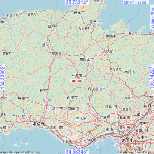
Tanba GPS coordinates[2]
35° 9' 37.224" North, 135° 2' 20.904" East
| Map corner | latitude | longitude |
|---|---|---|
| Upper-left | 35.73314°, | 134.33602° |
| Center: | 35.16034°, | 135.03914° |
| Lower-right: | 34.58348°, | 135.74227° |
| Map W x H: | 127.8×127.8 km | = 79.4×79.4mi |
| max Lat: | 45.40944° ⇑55% North |
| Tanba: | 35.16034° |
| min Lat: | ⇓45% South 24.34478° |
| min Long | Tanba | max Long |
| 123° | 135.03914° | 145.575° |
| W 29.5%⇐ | ⇒70.5% E |
Elevation
Elevation of Tanba is 91 m = 299 ft, and this is 6.4 m = 21 ft above average elevation for this country.
| Max E: |
1086 m = 3563 ft | 26.1% |
| Tanba | 91 m 299 ft | |
| Avg. | 84.6 m = 278 ft | |
Min E: |
-2 m = -7 ft | 73.9% |
See also: Japan elevation on elevation.city.
Geographical zone
Tanba is located in North temperate zone (between Tropic of Cancer and the Arctic Circle). Distance of this Northern Tropic circle is 1303.5 km =810 mi to South.| Distance of | km | miles | from Tanba |
|---|---|---|---|
| North Pole | 6097.6 | 3788.9 | to North |
| Arctic Circle | 3491.7 | 2169.6 | to North |
| Tropic Cancer | 1303.5 | 810 | to South |
| Equator | 3909.5 | 2429.2 | to South |


Nearby cities:
15 places around Tanba: (largest is in red/bold)
• Asago
23.2 km =14.4 mi,  298°
298°
• Ayabe
24.7 km =15.3 mi,  50°
50°
• Fukuchiyama
17.1 km =10.6 mi,  24°
24°
• Kasai
31.4 km =19.5 mi,  214°
214°
• Katō
26.3 km =16.3 mi,  182°
182°
• Maizuru
41.8 km =26 mi,  39°
39°
• Miki
40.4 km =25.1 mi,  187°
187°
• Nantan
41.5 km =25.8 mi,  97°
97°
• Nishiwaki
20.5 km =12.7 mi,  196°
196°
• Ono
35.8 km =22.2 mi, 195°
• Sanda
28.5 km =17.7 mi,  146°
146°
• Sandachō
35.1 km =21.8 mi, 150°
• Sasayama
19.2 km =11.9 mi,  122°
122°
• Yabu
36.3 km =22.6 mi,  317°
317°
• Yashiro
27.9 km =17.3 mi, 193°
Sources, notices
• [Note1] Compared only with cities in Japan existing in our database
• [Src1] Map data: © OpenStreetMap contributors (CC-BY-SA)
• [Src2] Other city data from geonames.org with taken over terms of usage.
• [Src3] Geographical zone / Annual Mean Temperature by Robert A. Rohde @ Wikipedia
