Nantan geodata
Nantan (Kyoto) is a seat of a second-order administrative division; located in Japan in Asia/Tokyo (GMT+9) time zone. In our database, there are 767 cities with bigger population. Compared to other cities in Japan, 56% of cities are located further ↑North; 66.9% of cities are located further →East and 91.1% of cities have lower elevation than Nantan. Note1


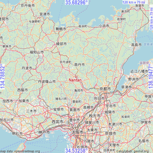
Nantan GPS coordinates[2]
35° 6' 35.28" North, 135° 29' 29.904" East
| Map corner | latitude | longitude |
|---|---|---|
| Upper-left | 35.68296°, | 134.78852° |
| Center: | 35.1098°, | 135.49164° |
| Lower-right: | 34.53258°, | 136.19477° |
| Map W x H: | 127.9×127.9 km | = 79.5×79.5mi |
| max Lat: | 45.40944° ⇑56% North |
| Nantan: | 35.1098° |
| min Lat: | ⇓44% South 24.34478° |
| min Long | Nantan | max Long |
| 123° | 135.49164° | 145.575° |
| W 33.1%⇐ | ⇒66.9% E |
Elevation
Elevation of Nantan is 248 m = 814 ft, and this is 163.4 m = 536 ft above average elevation for this country.
| Max E: |
1086 m = 3563 ft | 8.9% |
| Nantan | 248 m 814 ft | |
| Avg. | 84.6 m = 278 ft | |
Min E: |
-2 m = -7 ft | 91.1% |
See also: Japan elevation on elevation.city.
Geographical zone
Nantan is located in North temperate zone (between Tropic of Cancer and the Arctic Circle). Distance of this Northern Tropic circle is 1297.9 km =806.5 mi to South.| Distance of | km | miles | from Nantan |
|---|---|---|---|
| North Pole | 6103.2 | 3792.4 | to North |
| Arctic Circle | 3497.3 | 2173.1 | to North |
| Tropic Cancer | 1297.9 | 806.5 | to South |
| Equator | 3903.8 | 2425.7 | to South |


Nearby cities:
15 places around Nantan: (largest is in red/bold)
• Arashiyama
19.9 km =12.4 mi,  121°
121°
• Ayabe
30.5 km =19 mi,  313°
313°
• Ikeda
32.5 km =20.2 mi,  189°
189°
• Kameoka
14.8 km =9.2 mi,  145°
145°
• Kamigyō-ku
25.7 km =16 mi,  110°
110°
• Kawanishi
26.8 km =16.7 mi,  198°
198°
• Kawanishi
33.3 km =20.7 mi, 191°
• Kyoto
25.8 km =16 mi, 112°
• Mino
31.5 km =19.6 mi,  183°
183°
• Mukō
25.1 km =15.6 mi,  129°
129°
• Nagaoka
27 km =16.8 mi,  137°
137°
• Sanda
31.1 km =19.3 mi,  234°
234°
• Sasayama
25.5 km =15.8 mi,  259°
259°
• Takatsuki
31.2 km =19.4 mi,  158°
158°
• Yawata
32.9 km =20.4 mi, 144°
Sources, notices
• [Note1] Compared only with cities in Japan existing in our database
• [Src1] Map data: © OpenStreetMap contributors (CC-BY-SA)
• [Src2] Other city data from geonames.org with taken over terms of usage.
• [Src3] Geographical zone / Annual Mean Temperature by Robert A. Rohde @ Wikipedia
