Owase geodata
Owase (Mie) is a seat of a second-order administrative division; located in Japan in Asia/Tokyo (GMT+9) time zone. With population of 22,038 people, there are 662 cities with bigger population in this country. Compared to other cities in Japan, 79.4% of cities are located further ↑North; 59.7% of cities are located further →East and 93.5% of cities have higher elevation than Owase. Note1


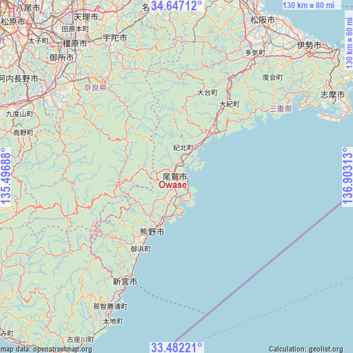
Owase GPS coordinates[2]
34° 4' 0.012" North, 136° 12' 0" East
| Map corner | latitude | longitude |
|---|---|---|
| Upper-left | 34.64712°, | 135.49688° |
| Center: | 34.06667°, | 136.2° |
| Lower-right: | 33.48221°, | 136.90313° |
| Map W x H: | 129.5×129.5 km | = 80.5×80.5mi |
| max Lat: | 45.40944° ⇑79.4% North |
| Owase: | 34.06667° |
| min Lat: | ⇓20.6% South 24.34478° |
| min Long | Owase | max Long |
| 123° | 136.2° | 145.575° |
| W 40.3%⇐ | ⇒59.7% E |
Elevation
Elevation of Owase is 4 m = 13 ft, and this is 80.6 m = 264 ft below average elevation for this country.
| Max E: |
1086 m = 3563 ft | 93.5% |
| Avg. | 84.6 m = 278 ft | |
| Owase | 4 m = 13 ft | |
Min E: |
-2 m = -7 ft | 6.5% |
See also: Japan elevation on elevation.city.
Geographical zone
Owase is located in North temperate zone (between Tropic of Cancer and the Arctic Circle). Distance of this Northern Tropic circle is 1181.9 km =734.4 mi to South.| Distance of | km | miles | from Owase |
|---|---|---|---|
| North Pole | 6219.2 | 3864.4 | to North |
| Arctic Circle | 3613.3 | 2245.2 | to North |
| Tropic Cancer | 1181.9 | 734.4 | to South |
| Equator | 3787.9 | 2353.7 | to South |


Nearby cities:
15 places around Owase: (largest is in red/bold)
• Gojō
55.7 km =34.6 mi,  304°
304°
• Gose
60.5 km =37.6 mi,  314°
314°
• Haibara-akanedai
56.7 km =35.2 mi,  336°
336°
• Hashimoto
60.4 km =37.5 mi, 297°
• Kashihara-shi
61.8 km =38.4 mi,  322°
322°
• Kihoku
20.2 km =12.6 mi,  37°
37°
• Kumano
19.5 km =12.1 mi,  201°
201°
• Kōya
55.6 km =34.5 mi,  287°
287°
• Matsusaka
64.8 km =40.3 mi,  28°
28°
• Minamiise
55.7 km =34.6 mi,  55°
55°
• Nabari
62.1 km =38.6 mi,  350°
350°
• Sakurai
57.9 km =36 mi,  326°
326°
• Shingū
42.1 km =26.2 mi,  208°
208°
• Yoshino-chō
48.3 km =30 mi, 319°
• Ōuda
50.8 km =31.6 mi, 331°
Sources, notices
• [Note1] Compared only with cities in Japan existing in our database
• [Src1] Map data: © OpenStreetMap contributors (CC-BY-SA)
• [Src2] Other city data from geonames.org with taken over terms of usage.
• [Src3] Geographical zone / Annual Mean Temperature by Robert A. Rohde @ Wikipedia
