Amami geodata
Amami (Kagoshima) is a seat of a second-order administrative division; located in Japan in Asia/Tokyo (GMT+9) time zone. In our database, there are 767 cities with bigger population. Compared to other cities in Japan, 98.2% of cities are located further ↑North; 98.1% of cities are located further →East and 57.5% of cities have higher elevation than Amami. Note1


Amami GPS coordinates[2]
28° 22' 36.84" North, 129° 29' 37.644" East
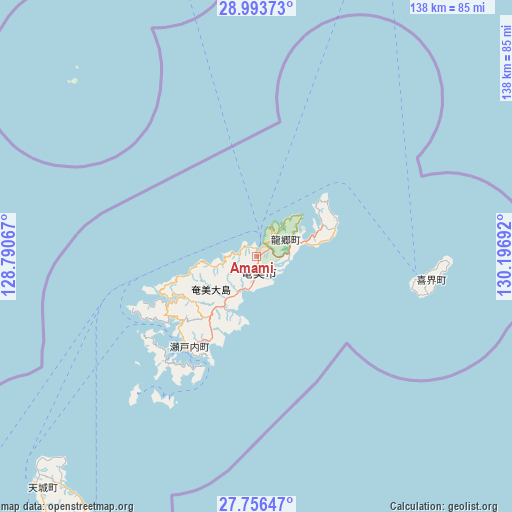
| Map corner | latitude | longitude |
|---|---|---|
| Upper-left | 28.99373°, | 128.79067° |
| Center: | 28.3769°, | 129.49379° |
| Lower-right: | 27.75647°, | 130.19692° |
| Map W x H: | 137.6×137.6 km | = 85.5×85.5mi |
| max Lat: | 45.40944° ⇑98.2% North |
| Amami: | 28.3769° |
| min Lat: | ⇓1.8% South 24.34478° |
| min Long | Amami | max Long |
| 123° | 129.49379° | 145.575° |
| W 1.9%⇐ | ⇒98.1% E |
Elevation
Elevation of Amami is 21 m = 69 ft, and this is 63.6 m = 209 ft below average elevation for this country.
| Max E: |
1086 m = 3563 ft | 57.5% |
| Avg. | 84.6 m = 278 ft | |
| Amami | 21 m = 69 ft | |
Min E: |
-2 m = -7 ft | 42.5% |
See also: Japan elevation on elevation.city.
Geographical zone
Amami is located in North temperate zone (between Tropic of Cancer and the Arctic Circle). Distance of this Northern Tropic circle is 549.3 km =341.3 mi to South.| Distance of | km | miles | from Amami |
|---|---|---|---|
| North Pole | 6851.8 | 4257.5 | to North |
| Arctic Circle | 4246 | 2638.3 | to North |
| Tropic Cancer | 549.3 | 341.3 | to South |
| Equator | 3155.2 | 1960.5 | to South |


Nearby cities:
15 places around Amami: (largest is in red/bold)
• Chatan
286 km =177.7 mi,  216°
216°
• Ginowan
290.8 km =180.7 mi, 216°
• Gushikawa
275.9 km =171.4 mi, 215°
• Ishikawa
272.8 km =169.5 mi, 217°
• Katsuren-haebaru
277.9 km =172.7 mi, 215°
• Koseda
250.1 km =155.4 mi,  26°
26°
• Koshima
229.9 km =142.9 mi, 26°
• Kurio
229.1 km =142.4 mi,  23°
23°
• Miyanoura
250.7 km =155.8 mi, 24°
• Nagata
241.9 km =150.3 mi, 21°
• Nago
246 km =152.9 mi, 217°
• Naze
1.5 km =0.9 mi, 221°
• Okinawa
281.8 km =175.1 mi, 216°
• Uruma
274.8 km =170.8 mi, 215°
• Yudomari
227.6 km =141.4 mi, 24°
Sources, notices
• [Note1] Compared only with cities in Japan existing in our database
• [Src1] Map data: © OpenStreetMap contributors (CC-BY-SA)
• [Src2] Other city data from geonames.org with taken over terms of usage.
• [Src3] Geographical zone / Annual Mean Temperature by Robert A. Rohde @ Wikipedia
