Maizuru geodata
Maizuru (Kyoto) is a seat of a second-order administrative division; located in Japan in Asia/Tokyo (GMT+9) time zone. With population of 92,465 people, there are 218 cities with bigger population in this country. Compared to other cities in Japan, 52.5% of cities are located further ↓South; 68.4% of cities are located further →East and 86% of cities have higher elevation than Maizuru. Note1


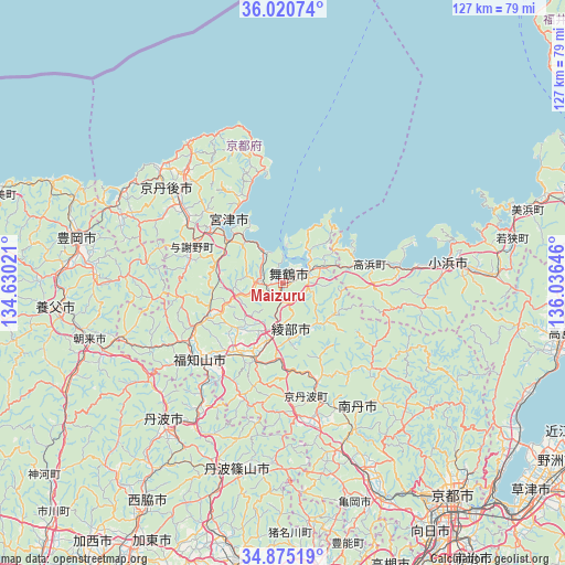
Maizuru GPS coordinates[2]
35° 27' 0" North, 135° 19' 59.988" East
| Map corner | latitude | longitude |
|---|---|---|
| Upper-left | 36.02074°, | 134.63021° |
| Center: | 35.45°, | 135.33333° |
| Lower-right: | 34.87519°, | 136.03646° |
| Map W x H: | 127.4×127.4 km | = 79.2×79.2mi |
| max Lat: | 45.40944° ⇑47.5% North |
| Maizuru: | 35.45° |
| min Lat: | ⇓52.5% South 24.34478° |
| min Long | Maizuru | max Long |
| 123° | 135.33333° | 145.575° |
| W 31.6%⇐ | ⇒68.4% E |
Elevation
Elevation of Maizuru is 6 m = 20 ft, and this is 78.6 m = 258 ft below average elevation for this country.
| Max E: |
1086 m = 3563 ft | 86% |
| Avg. | 84.6 m = 278 ft | |
| Maizuru | 6 m = 20 ft | |
Min E: |
-2 m = -7 ft | 14% |
See also: Maizuru elevation on elevation.city.
Geographical zone
Maizuru is located in North temperate zone (between Tropic of Cancer and the Arctic Circle). Distance of this Northern Tropic circle is 1335.8 km =830 mi to South.| Distance of | km | miles | from Maizuru |
|---|---|---|---|
| North Pole | 6065.4 | 3768.9 | to North |
| Arctic Circle | 3459.5 | 2149.6 | to North |
| Tropic Cancer | 1335.8 | 830 | to South |
| Equator | 3941.7 | 2449.3 | to South |


Nearby cities:
15 places around Maizuru: (largest is in red/bold)
• Arashiyama
57.6 km =35.8 mi,  147°
147°
• Asago
51.7 km =32.1 mi,  245°
245°
• Ayabe
18.3 km =11.4 mi,  204°
204°
• Fukuchiyama
25.8 km =16 mi,  229°
229°
• Kameoka
54.9 km =34.1 mi,  155°
155°
• Kamigyō-ku
60.5 km =37.6 mi,  140°
140°
• Kyōtango
31.4 km =19.5 mi,  303°
303°
• Miyazu
16.4 km =10.2 mi, 304°
• Nantan
40.5 km =25.2 mi, 159°
• Obama
37.7 km =23.4 mi,  82°
82°
• Sanda
57 km =35.4 mi,  190°
190°
• Sasayama
43.9 km =27.3 mi, 193°
• Tanba
41.8 km =26 mi,  219°
219°
• Toyooka
47.5 km =29.5 mi,  282°
282°
• Yabu
51.2 km =31.8 mi,  264°
264°
Sources, notices
• [Note1] Compared only with cities in Japan existing in our database
• [Src1] Map data: © OpenStreetMap contributors (CC-BY-SA)
• [Src2] Other city data from geonames.org with taken over terms of usage.
• [Src3] Geographical zone / Annual Mean Temperature by Robert A. Rohde @ Wikipedia
