Eldama Ravine geodata
Eldama Ravine (Baringo) is a populated place; located in Kenya in Africa/Nairobi (GMT+3) time zone. With population of 12,524 people, there are 57 cities with bigger population in this country. Compared to other cities in Kenya, 67.5% of cities are located further ↓South; 61.4% of cities are located further →East and 89.5% of cities have lower elevation than Eldama Ravine. Note1


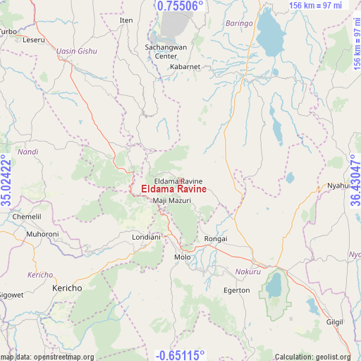
Eldama Ravine GPS coordinates[2]
0° 3' 7.056" North, 35° 43' 38.424" East
| Map corner | latitude | longitude |
|---|---|---|
| Upper-left | 0.75506°, | 35.02422° |
| Center: | 0.05196°, | 35.72734° |
| Lower-right: | -0.65115°, | 36.43047° |
| Map W x H: | 156.4×156.4 km | = 97.2×97.2mi |
| max Lat: | 3.93726° ⇑32.5% North |
| Eldama Ravine: | 0.05196° |
| min Lat: | ⇓67.5% South -4.64756° |
| min Long | Eldama Ravine | max Long |
| 33.97248° | 35.72734° | 41.85688° |
| W 38.6%⇐ | ⇒61.4% E |
Elevation
Elevation of Eldama Ravine is 2047 m = 6716 ft, and this is 700.3 m = 2298 ft above average elevation for this country.
| Max E: |
2514 m = 8248 ft | 10.5% |
| Eldama Ravine | 2047 m 6716 ft | |
| Avg. | 1346.7 m = 4418 ft | |
Min E: |
7 m = 23 ft | 89.5% |
See also: Kenya elevation on elevation.city.
Geographical zone
Eldama Ravine is located in North Torrid zone (between Equator and Tropic of Cancer). Distance of Equator is 5.8 km =3.6 mi to South.| Distance of | km | miles | from Eldama Ravine |
|---|---|---|---|
| North Pole | 10001.3 | 6214.5 | to North |
| Arctic Circle | 7395.4 | 4595.3 | to North |
| Tropic Cancer | 2600.1 | 1615.6 | to North |
| Equator | 5.8 | 3.6 | to South |


Nearby cities:
15 places around Eldama Ravine: (largest is in red/bold)
• Baringo
53.2 km =33.1 mi,  29°
29°
• Eldoret
72.8 km =45.2 mi,  315°
315°
• Iten
72.9 km =45.3 mi,  340°
340°
• Kabarnet
49 km =30.4 mi,  2°
2°
• Kapsabet
71.2 km =44.2 mi,  283°
283°
• Kericho
67.9 km =42.2 mi,  226°
226°
• Kipkelion
40.2 km =25 mi, 225°
• Londiani
28.4 km =17.6 mi,  211°
211°
• Molo
33.4 km =20.8 mi,  179°
179°
• Muhoroni
63.5 km =39.5 mi,  248°
248°
• Nakuru
55.4 km =34.4 mi,  136°
136°
• Nandi Hills
60.7 km =37.7 mi, 275°
• Nyahururu
70.7 km =43.9 mi,  91°
91°
• Ol Kalou
80.9 km =50.3 mi,  116°
116°
• Rongai
29.3 km =18.2 mi,  148°
148°
Sources, notices
• [Note1] Compared only with cities in Kenya existing in our database
• [Src1] Map data: © OpenStreetMap contributors (CC-BY-SA)
• [Src2] Other city data from geonames.org with taken over terms of usage.
• [Src3] Geographical zone / Annual Mean Temperature by Robert A. Rohde @ Wikipedia
