Webuye geodata
Webuye (Bungoma) is a populated place; located in Kenya in Africa/Nairobi (GMT+3) time zone. With population of 22,507 people, there are 41 cities with bigger population in this country. Compared to other cities in Kenya, 88.6% of cities are located further ↓South; 78.9% of cities are located further →East and 53.5% of cities have lower elevation than Webuye. Note1


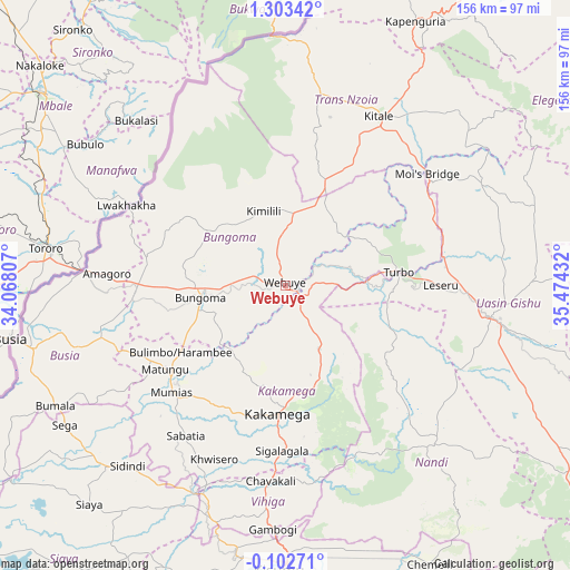
Webuye GPS coordinates[2]
0° 36' 1.44" North, 34° 46' 16.284" East
| Map corner | latitude | longitude |
|---|---|---|
| Upper-left | 1.30342°, | 34.06807° |
| Center: | 0.6004°, | 34.77119° |
| Lower-right: | -0.10271°, | 35.47432° |
| Map W x H: | 156.3×156.4 km | = 97.1×97.2mi |
| max Lat: | 3.93726° ⇑11.4% North |
| Webuye: | 0.6004° |
| min Lat: | ⇓88.6% South -4.64756° |
| min Long | Webuye | max Long |
| 33.97248° | 34.77119° | 41.85688° |
| W 21.1%⇐ | ⇒78.9% E |
Elevation
Elevation of Webuye is 1502 m = 4928 ft, and this is 155.3 m = 510 ft above average elevation for this country.
| Max E: |
2514 m = 8248 ft | 46.5% |
| Webuye | 1502 m 4928 ft | |
| Avg. | 1346.7 m = 4418 ft | |
Min E: |
7 m = 23 ft | 53.5% |
See also: Kenya elevation on elevation.city.
Geographical zone
Webuye is located in North Torrid zone (between Equator and Tropic of Cancer). Distance of Equator is 66.8 km =41.5 mi to South.| Distance of | km | miles | from Webuye |
|---|---|---|---|
| North Pole | 9940.3 | 6176.6 | to North |
| Arctic Circle | 7334.4 | 4557.4 | to North |
| Tropic Cancer | 2539.2 | 1577.8 | to North |
| Equator | 66.8 | 41.5 | to South |


Nearby cities:
15 places around Webuye: (largest is in red/bold)
• Bondo
68 km =42.3 mi,  233°
233°
• Bungoma
21 km =13 mi,  264°
264°
• Bungoma
23.8 km =14.8 mi, 260°
• Butere
53.8 km =33.4 mi,  215°
215°
• Eldoret
56.2 km =34.9 mi,  99°
99°
• Kakamega
35.2 km =21.9 mi,  183°
183°
• Kapsabet
57.6 km =35.8 mi,  139°
139°
• Kitale
53.1 km =33 mi,  29°
29°
• Lugulu
56.8 km =35.3 mi,  246°
246°
• Malaba
54.6 km =33.9 mi,  274°
274°
• Malikisi
39.8 km =24.7 mi,  282°
282°
• Mbale
57.9 km =36 mi,  185°
185°
• Mumias
43.2 km =26.8 mi, 226°
• Nambare
59.7 km =37.1 mi, 254°
• Yala
62 km =38.5 mi,  204°
204°
Sources, notices
• [Note1] Compared only with cities in Kenya existing in our database
• [Src1] Map data: © OpenStreetMap contributors (CC-BY-SA)
• [Src2] Other city data from geonames.org with taken over terms of usage.
• [Src3] Geographical zone / Annual Mean Temperature by Robert A. Rohde @ Wikipedia
