Sekseūil geodata
Sekseūil (Qyzylorda) is a populated place; located in Kazakhstan in Asia/Qyzylorda (GMT+5) time zone. With population of 9,296 people, there are 128 cities with bigger population in this country. Compared to other cities in Kazakhstan, 61.5% of cities are located further ↑North; 80.7% of cities are located further →East and 86.3% of cities have higher elevation than Sekseūil. Note1


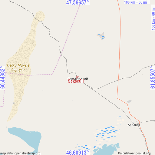
Sekseūil GPS coordinates[2]
47° 5' 24" North, 61° 9' 6.984" East
| Map corner | latitude | longitude |
|---|---|---|
| Upper-left | 47.56657°, | 60.44882° |
| Center: | 47.09°, | 61.15194° |
| Lower-right: | 46.60913°, | 61.85507° |
| Map W x H: | 106.5×106.5 km | = 66.2×66.2mi |
| max Lat: | 54.90596° ⇑61.5% North |
| Sekseūil: | 47.09° |
| min Lat: | ⇓38.5% South 40.66338° |
| min Long | Sekseūil | max Long |
| 46.83361° | 61.15194° | 84.87144° |
| W 19.3%⇐ | ⇒80.7% E |
Elevation
Elevation of Sekseūil is 73 m = 240 ft, and this is 283.5 m = 930 ft below average elevation for this country.
| Max E: |
1847 m = 6060 ft | 86.3% |
| Avg. | 356.5 m = 1170 ft | |
| Sekseūil | 73 m = 240 ft | |
Min E: |
-26 m = -85 ft | 13.7% |
See also: Kazakhstan elevation on elevation.city.
Geographical zone
Sekseūil is located in North temperate zone (between Tropic of Cancer and the Arctic Circle). Distance of this North polar circle is 2165.3 km =1345.5 mi to North.| Distance of | km | miles | from Sekseūil |
|---|---|---|---|
| North Pole | 4771.1 | 2964.6 | to North |
| Arctic Circle | 2165.3 | 1345.5 | to North |
| Tropic Cancer | 2630 | 1634.2 | to South |
| Equator | 5235.9 | 3253.4 | to South |


Nearby cities:
10 places around Sekseūil: (largest is in red/bold)
• Aral
50.7 km =31.5 mi,  129°
129°
• Ayteke Bi
158.1 km =98.2 mi,  151°
151°
• Baikonur
233.3 km =145 mi, 134°
• Embi
295.5 km =183.6 mi,  310°
310°
• Qazaly
164.7 km =102.3 mi, 153°
• Shalqar
143 km =88.9 mi, 305°
• Torghay
331.7 km =206.1 mi,  31°
31°
• Tyuratam
230.4 km =143.2 mi, 134°
• Yrghyz
170 km =105.6 mi,  2°
2°
• Zhosaly
286.8 km =178.2 mi, 128°
Sources, notices
• [Note1] Compared only with cities in Kazakhstan existing in our database
• [Src1] Map data: © OpenStreetMap contributors (CC-BY-SA)
• [Src2] Other city data from geonames.org with taken over terms of usage.
• [Src3] Geographical zone / Annual Mean Temperature by Robert A. Rohde @ Wikipedia
