Ayteke Bi geodata
Ayteke Bi (Qyzylorda) is a populated place; located in Kazakhstan in Asia/Qyzylorda (GMT+5) time zone. With population of 35,883 people, there are 43 cities with bigger population in this country. Compared to other cities in Kazakhstan, 67.8% of cities are located further ↑North; 78.1% of cities are located further →East and 87% of cities have higher elevation than Ayteke Bi. Note1


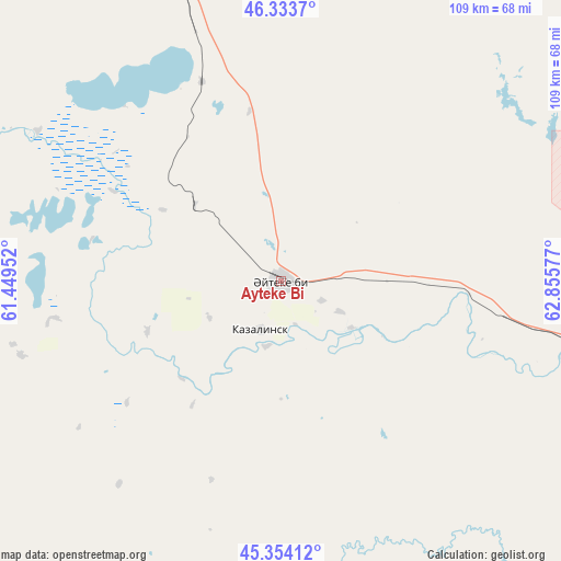
Ayteke Bi GPS coordinates[2]
45° 50' 45.852" North, 62° 9' 9.504" East
| Map corner | latitude | longitude |
|---|---|---|
| Upper-left | 46.3337°, | 61.44952° |
| Center: | 45.84607°, | 62.15264° |
| Lower-right: | 45.35412°, | 62.85577° |
| Map W x H: | 108.9×108.9 km | = 67.7×67.7mi |
| max Lat: | 54.90596° ⇑67.8% North |
| Ayteke Bi: | 45.84607° |
| min Lat: | ⇓32.2% South 40.66338° |
| min Long | Ayteke Bi | max Long |
| 46.83361° | 62.15264° | 84.87144° |
| W 21.9%⇐ | ⇒78.1% E |
Elevation
Elevation of Ayteke Bi is 70 m = 230 ft, and this is 286.5 m = 940 ft below average elevation for this country.
| Max E: |
1847 m = 6060 ft | 87% |
| Avg. | 356.5 m = 1170 ft | |
| Ayteke Bi | 70 m = 230 ft | |
Min E: |
-26 m = -85 ft | 13% |
See also: Kazakhstan elevation on elevation.city.
Geographical zone
Ayteke Bi is located in North temperate zone (between Tropic of Cancer and the Arctic Circle). Distance of this North polar circle is 2303.6 km =1431.4 mi to North.| Distance of | km | miles | from Ayteke Bi |
|---|---|---|---|
| North Pole | 4909.5 | 3050.6 | to North |
| Arctic Circle | 2303.6 | 1431.4 | to North |
| Tropic Cancer | 2491.7 | 1548.3 | to South |
| Equator | 5097.6 | 3167.5 | to South |


Nearby cities:
13 places around Ayteke Bi: (largest is in red/bold)
• Aral
112.4 km =69.8 mi,  340°
340°
• Baikonur
93.9 km =58.3 mi,  105°
105°
• Belköl
292.1 km =181.5 mi, 113°
• Dzhalagash
213.6 km =132.7 mi, 113°
• Kyzylorda
284.6 km =176.8 mi, 112°
• Qazaly
9.9 km =6.2 mi,  200°
200°
• Sekseūil
158.1 km =98.2 mi,  331°
331°
• Shalqar
294.1 km =182.7 mi,  318°
318°
• Tasböget
291.3 km =181 mi, 114°
• Terenozek
237.9 km =147.8 mi, 111°
• Tyuratam
92.5 km =57.5 mi,  103°
103°
• Yrghyz
315.2 km =195.9 mi,  347°
347°
• Zhosaly
154.8 km =96.2 mi, 104°
Sources, notices
• [Note1] Compared only with cities in Kazakhstan existing in our database
• [Src1] Map data: © OpenStreetMap contributors (CC-BY-SA)
• [Src2] Other city data from geonames.org with taken over terms of usage.
• [Src3] Geographical zone / Annual Mean Temperature by Robert A. Rohde @ Wikipedia
