Shalqar geodata
Shalqar (Aqtöbe) is a populated place; located in Kazakhstan in Asia/Aqtobe (GMT+5) time zone. With population of 27,399 people, there are 54 cities with bigger population in this country. Compared to other cities in Kazakhstan, 56.7% of cities are located further ↑North; 81.1% of cities are located further →East and 73.3% of cities have higher elevation than Shalqar. Note1


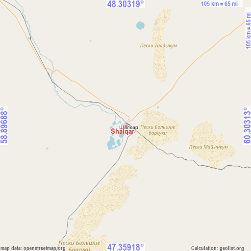
Shalqar GPS coordinates[2]
47° 49' 59.988" North, 59° 36' 0" East
| Map corner | latitude | longitude |
|---|---|---|
| Upper-left | 48.30319°, | 58.89688° |
| Center: | 47.83333°, | 59.6° |
| Lower-right: | 47.35918°, | 60.30313° |
| Map W x H: | 105×105 km | = 65.2×65.2mi |
| max Lat: | 54.90596° ⇑56.7% North |
| Shalqar: | 47.83333° |
| min Lat: | ⇓43.3% South 40.66338° |
| min Long | Shalqar | max Long |
| 46.83361° | 59.6° | 84.87144° |
| W 18.9%⇐ | ⇒81.1% E |
Elevation
Elevation of Shalqar is 164 m = 538 ft, and this is 192.5 m = 632 ft below average elevation for this country.
| Max E: |
1847 m = 6060 ft | 73.3% |
| Avg. | 356.5 m = 1170 ft | |
| Shalqar | 164 m = 538 ft | |
Min E: |
-26 m = -85 ft | 26.7% |
See also: Kazakhstan elevation on elevation.city.
Geographical zone
Shalqar is located in North temperate zone (between Tropic of Cancer and the Arctic Circle). Distance of this North polar circle is 2082.6 km =1294.1 mi to North.| Distance of | km | miles | from Shalqar |
|---|---|---|---|
| North Pole | 4688.5 | 2913.3 | to North |
| Arctic Circle | 2082.6 | 1294.1 | to North |
| Tropic Cancer | 2712.6 | 1685.5 | to South |
| Equator | 5318.6 | 3304.8 | to South |


Nearby cities:
14 places around Shalqar: (largest is in red/bold)
• Aktobe
323.1 km =200.8 mi,  327°
327°
• Aral
193.6 km =120.3 mi,  126°
126°
• Ayteke Bi
294.1 km =182.7 mi,  138°
138°
• Batamshinskiy
318.1 km =197.7 mi,  342°
342°
• Bayganin
291.7 km =181.3 mi,  289°
289°
• Embi
154.1 km =95.8 mi,  315°
315°
• Kandyagash
242.4 km =150.6 mi, 318°
• Khromtau
281.8 km =175.1 mi, 342°
• Qazaly
299 km =185.8 mi, 140°
• Sekseūil
143 km =88.9 mi, 125°
• Shubarkuduk
272.1 km =169.1 mi,  302°
302°
• Shubarshi
197.4 km =122.7 mi, 294°
• Temir
233.1 km =144.8 mi,  308°
308°
• Yrghyz
151.1 km =93.9 mi,  54°
54°
Sources, notices
• [Note1] Compared only with cities in Kazakhstan existing in our database
• [Src1] Map data: © OpenStreetMap contributors (CC-BY-SA)
• [Src2] Other city data from geonames.org with taken over terms of usage.
• [Src3] Geographical zone / Annual Mean Temperature by Robert A. Rohde @ Wikipedia
