Tyuratam geodata
Tyuratam (Baikonur) is a populated place; located in Kazakhstan in Asia/Qostanay (GMT+5) time zone. With population of 9,548 people, there are 124 cities with bigger population in this country. Compared to other cities in Kazakhstan, 68.5% of cities are located further ↑North; 75.6% of cities are located further →East and 82.2% of cities have higher elevation than Tyuratam. Note1


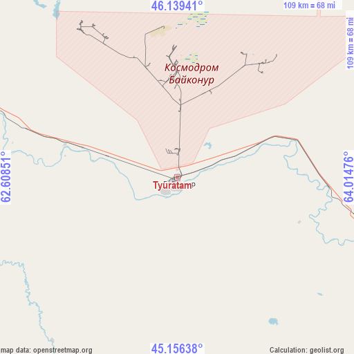
Tyuratam GPS coordinates[2]
45° 39' 0.18" North, 63° 18' 41.868" East
| Map corner | latitude | longitude |
|---|---|---|
| Upper-left | 46.13941°, | 62.60851° |
| Center: | 45.65005°, | 63.31163° |
| Lower-right: | 45.15638°, | 64.01476° |
| Map W x H: | 109.3×109.3 km | = 67.9×67.9mi |
| max Lat: | 54.90596° ⇑68.5% North |
| Tyuratam: | 45.65005° |
| min Lat: | ⇓31.5% South 40.66338° |
| min Long | Tyuratam | max Long |
| 46.83361° | 63.31163° | 84.87144° |
| W 24.4%⇐ | ⇒75.6% E |
Elevation
Elevation of Tyuratam is 106 m = 348 ft, and this is 250.5 m = 822 ft below average elevation for this country.
| Max E: |
1847 m = 6060 ft | 82.2% |
| Avg. | 356.5 m = 1170 ft | |
| Tyuratam | 106 m = 348 ft | |
Min E: |
-26 m = -85 ft | 17.8% |
See also: Kazakhstan elevation on elevation.city.
Geographical zone
Tyuratam is located in North temperate zone (between Tropic of Cancer and the Arctic Circle). Distance of this North polar circle is 2325.4 km =1444.9 mi to North.| Distance of | km | miles | from Tyuratam |
|---|---|---|---|
| North Pole | 4931.3 | 3064.2 | to North |
| Arctic Circle | 2325.4 | 1444.9 | to North |
| Tropic Cancer | 2469.9 | 1534.7 | to South |
| Equator | 5075.8 | 3154 | to South |


Nearby cities:
14 places around Tyuratam: (largest is in red/bold)
• Aral
179.9 km =111.8 mi,  315°
315°
• Ayteke Bi
92.5 km =57.5 mi,  283°
283°
• Baikonur
3.7 km =2.3 mi,  173°
173°
• Belköl
201.1 km =125 mi,  117°
117°
• Dzhalagash
123.2 km =76.6 mi, 120°
• Kyzylorda
193.5 km =120.2 mi, 117°
• Qazaly
94.3 km =58.6 mi, 277°
• Sekseūil
230.4 km =143.2 mi,  314°
314°
• Shīeli
316.1 km =196.4 mi, 121°
• Tasböget
200.7 km =124.7 mi, 119°
• Terenozek
146.7 km =91.2 mi, 117°
• Torghay
443.2 km =275.4 mi,  1°
1°
• Yrghyz
364.3 km =226.4 mi,  334°
334°
• Zhosaly
62.3 km =38.7 mi,  106°
106°
Sources, notices
• [Note1] Compared only with cities in Kazakhstan existing in our database
• [Src1] Map data: © OpenStreetMap contributors (CC-BY-SA)
• [Src2] Other city data from geonames.org with taken over terms of usage.
• [Src3] Geographical zone / Annual Mean Temperature by Robert A. Rohde @ Wikipedia
