Aral geodata
Aral (Qyzylorda) is a populated place; located in Kazakhstan in Asia/Qyzylorda (GMT+5) time zone. With population of 33,017 people, there are 50 cities with bigger population in this country. Compared to other cities in Kazakhstan, 64.1% of cities are located further ↑North; 79.6% of cities are located further →East and 88.5% of cities have higher elevation than Aral. Note1


Aral GPS coordinates[2]
46° 48' 0" North, 61° 40' 0.012" East
| Map corner | latitude | longitude |
|---|---|---|
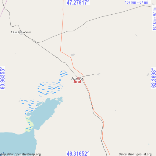
| Upper-left | 47.27917°, | 60.96355° |
| Center: | 46.8°, | 61.66667° |
| Lower-right: | 46.31652°, | 62.3698° |
| Map W x H: | 107×107 km | = 66.5×66.5mi |
| max Lat: | 54.90596° ⇑64.1% North |
| Aral: | 46.8° |
| min Lat: | ⇓35.9% South 40.66338° |
| min Long | Aral | max Long |
| 46.83361° | 61.66667° | 84.87144° |
| W 20.4%⇐ | ⇒79.6% E |
Elevation
Elevation of Aral is 57 m = 187 ft, and this is 299.5 m = 983 ft below average elevation for this country.
| Max E: |
1847 m = 6060 ft | 88.5% |
| Avg. | 356.5 m = 1170 ft | |
| Aral | 57 m = 187 ft | |
Min E: |
-26 m = -85 ft | 11.5% |
See also: Kazakhstan elevation on elevation.city.
Geographical zone
Aral is located in North temperate zone (between Tropic of Cancer and the Arctic Circle). Distance of this North polar circle is 2197.5 km =1365.5 mi to North.| Distance of | km | miles | from Aral |
|---|---|---|---|
| North Pole | 4803.4 | 2984.7 | to North |
| Arctic Circle | 2197.5 | 1365.5 | to North |
| Tropic Cancer | 2597.8 | 1614.2 | to South |
| Equator | 5203.7 | 3233.4 | to South |


Nearby cities:
11 places around Aral: (largest is in red/bold)
• Ayteke Bi
112.4 km =69.8 mi,  160°
160°
• Baikonur
182.8 km =113.6 mi,  136°
136°
• Dzhalagash
300.4 km =186.7 mi,  129°
129°
• Qazaly
120.2 km =74.7 mi, 163°
• Sekseūil
50.7 km =31.5 mi,  309°
309°
• Shalqar
193.6 km =120.3 mi, 306°
• Terenozek
321.9 km =200 mi, 127°
• Torghay
343 km =213.1 mi,  23°
23°
• Tyuratam
179.9 km =111.8 mi, 135°
• Yrghyz
204.2 km =126.9 mi,  351°
351°
• Zhosaly
236.2 km =146.8 mi, 128°
Sources, notices
• [Note1] Compared only with cities in Kazakhstan existing in our database
• [Src1] Map data: © OpenStreetMap contributors (CC-BY-SA)
• [Src2] Other city data from geonames.org with taken over terms of usage.
• [Src3] Geographical zone / Annual Mean Temperature by Robert A. Rohde @ Wikipedia
