Ust-Kamenogorsk geodata
Ust-Kamenogorsk (East Kazakhstan) is a seat of a first-order administrative division; located in Kazakhstan in Asia/Almaty (GMT+5) time zone. With population of 319,067 people, there are 6 cities with bigger population in this country. Compared to other cities in Kazakhstan, 64.4% of cities are located further ↓South; 95.6% of cities are located further ←West and 53.7% of cities have higher elevation than Ust-Kamenogorsk. Note1


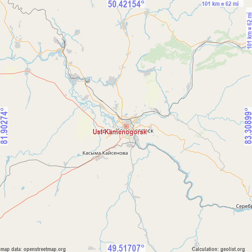
Ust-Kamenogorsk GPS coordinates[2]
49° 58' 17.148" North, 82° 36' 21.096" East
| Map corner | latitude | longitude |
|---|---|---|
| Upper-left | 50.42154°, | 81.90274° |
| Center: | 49.97143°, | 82.60586° |
| Lower-right: | 49.51707°, | 83.30899° |
| Map W x H: | 100.6×100.6 km | = 62.5×62.5mi |
| max Lat: | 54.90596° ⇑35.6% North |
| Ust-Kamenogorsk: | 49.97143° |
| min Lat: | ⇓64.4% South 40.66338° |
| min Long | Ust-Kamenogorsk | max Long |
| 46.83361° | 82.60586° | 84.87144° |
| W 95.6%⇐ | ⇒4.4% E |
Elevation
Elevation of Ust-Kamenogorsk is 287 m = 942 ft, and this is 69.5 m = 228 ft below average elevation for this country.
| Max E: |
1847 m = 6060 ft | 53.7% |
| Avg. | 356.5 m = 1170 ft | |
| Ust-Kamenogorsk | 287 m = 942 ft | |
Min E: |
-26 m = -85 ft | 46.3% |
See also: Ust-Kamenogorsk elevation on elevation.city.
Geographical zone
Ust-Kamenogorsk is located in North temperate zone (between Tropic of Cancer and the Arctic Circle). Distance of this North polar circle is 1844.9 km =1146.4 mi to North.| Distance of | km | miles | from Ust-Kamenogorsk |
|---|---|---|---|
| North Pole | 4450.8 | 2765.6 | to North |
| Arctic Circle | 1844.9 | 1146.4 | to North |
| Tropic Cancer | 2950.4 | 1833.3 | to South |
| Equator | 5556.3 | 3452.5 | to South |


Nearby cities:
15 places around Ust-Kamenogorsk: (largest is in red/bold)
• Altayskiy
35.1 km =21.8 mi,  330°
330°
• Asūbulaq
56.6 km =35.2 mi,  144°
144°
• Auezov
79.1 km =49.2 mi,  248°
248°
• Belogorskīy
67.4 km =41.9 mi, 144°
• Belousovka
18.9 km =11.7 mi,  342°
342°
• Georgīevka
103.2 km =64.1 mi,  226°
226°
• Glubokoye
28.1 km =17.5 mi,  311°
311°
• Ognevka
43.5 km =27 mi, 137°
• Pervorosiyskiy
93.5 km =58.1 mi,  107°
107°
• Ridder
76.8 km =47.7 mi,  57°
57°
• Shar
119.7 km =74.4 mi, 249°
• Shemonaīkha
88.1 km =54.7 mi, 325°
• Suykbulak
115.4 km =71.7 mi,  255°
255°
• Zhanga Buqtyrma
76.1 km =47.3 mi,  119°
119°
• Ūst’-Talovka
83.8 km =52.1 mi,  320°
320°
In other languages:
- In France: Öskemen
- In German: Öskemen, Ust-Kamenogorsk
- In Russian: Усть-Каменогорск
Sources, notices
• [Note1] Compared only with cities in Kazakhstan existing in our database
• [Src1] Map data: © OpenStreetMap contributors (CC-BY-SA)
• [Src2] Other city data from geonames.org with taken over terms of usage.
• [Src3] Geographical zone / Annual Mean Temperature by Robert A. Rohde @ Wikipedia
