Altayskiy geodata
Altayskiy (East Kazakhstan) is a populated place; located in Kazakhstan in Asia/Almaty (GMT+5) time zone. With population of 2,678 people, there are 232 cities with bigger population in this country. Compared to other cities in Kazakhstan, 67.8% of cities are located further ↓South; 94.1% of cities are located further ←West and 58.1% of cities have lower elevation than Altayskiy. Note1


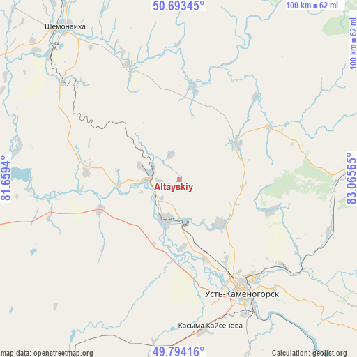
Altayskiy GPS coordinates[2]
50° 14' 45.348" North, 82° 21' 45.072" East
| Map corner | latitude | longitude |
|---|---|---|
| Upper-left | 50.69345°, | 81.6594° |
| Center: | 50.24593°, | 82.36252° |
| Lower-right: | 49.79416°, | 83.06565° |
| Map W x H: | 100×100 km | = 62.1×62.1mi |
| max Lat: | 54.90596° ⇑32.2% North |
| Altayskiy: | 50.24593° |
| min Lat: | ⇓67.8% South 40.66338° |
| min Long | Altayskiy | max Long |
| 46.83361° | 82.36252° | 84.87144° |
| W 94.1%⇐ | ⇒5.9% E |
Elevation
Elevation of Altayskiy is 380 m = 1247 ft, and this is 23.5 m = 77 ft above average elevation for this country.
| Max E: |
1847 m = 6060 ft | 41.9% |
| Altayskiy | 380 m 1247 ft | |
| Avg. | 356.5 m = 1170 ft | |
Min E: |
-26 m = -85 ft | 58.1% |
See also: Kazakhstan elevation on elevation.city.
Geographical zone
Altayskiy is located in North temperate zone (between Tropic of Cancer and the Arctic Circle). Distance of this North polar circle is 1814.4 km =1127.4 mi to North.| Distance of | km | miles | from Altayskiy |
|---|---|---|---|
| North Pole | 4420.2 | 2746.6 | to North |
| Arctic Circle | 1814.4 | 1127.4 | to North |
| Tropic Cancer | 2980.9 | 1852.2 | to South |
| Equator | 5586.8 | 3471.5 | to South |


Nearby cities:
15 places around Altayskiy: (largest is in red/bold)
• Asūbulaq
91.6 km =56.9 mi,  146°
146°
• Auezov
81.7 km =50.8 mi,  223°
223°
• Belogorskīy
102.4 km =63.6 mi, 146°
• Belousovka
17.1 km =10.6 mi,  137°
137°
• Borodulikha
114.2 km =71 mi,  297°
297°
• Georgīevka
116.8 km =72.6 mi,  208°
208°
• Glubokoye
12.5 km =7.8 mi,  197°
197°
• Ognevka
78.1 km =48.5 mi, 143°
• Ridder
82.4 km =51.2 mi,  82°
82°
• Shemonaīkha
53.1 km =33 mi,  323°
323°
• Suykbulak
111.4 km =69.2 mi,  237°
237°
• Ust-Kamenogorsk
35.1 km =21.8 mi, 150°
• Zhanga Buqtyrma
107.8 km =67 mi,  129°
129°
• Zhezkent
103.9 km =64.6 mi, 317°
• Ūst’-Talovka
49.6 km =30.8 mi,  312°
312°
Sources, notices
• [Note1] Compared only with cities in Kazakhstan existing in our database
• [Src1] Map data: © OpenStreetMap contributors (CC-BY-SA)
• [Src2] Other city data from geonames.org with taken over terms of usage.
• [Src3] Geographical zone / Annual Mean Temperature by Robert A. Rohde @ Wikipedia
