Georgīevka geodata
Georgīevka (East Kazakhstan) is a populated place; located in Kazakhstan in Asia/Almaty (GMT+5) time zone. With population of 22,047 people, there are 61 cities with bigger population in this country. Compared to other cities in Kazakhstan, 54.4% of cities are located further ↓South; 91.5% of cities are located further ←West and 64.4% of cities have lower elevation than Georgīevka. Note1


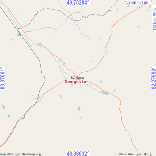
Georgīevka GPS coordinates[2]
49° 19' 36.156" North, 81° 34' 25.428" East
| Map corner | latitude | longitude |
|---|---|---|
| Upper-left | 49.78284°, | 80.87061° |
| Center: | 49.32671°, | 81.57373° |
| Lower-right: | 48.86632°, | 82.27686° |
| Map W x H: | 101.9×101.9 km | = 63.3×63.3mi |
| max Lat: | 54.90596° ⇑45.6% North |
| Georgīevka: | 49.32671° |
| min Lat: | ⇓54.4% South 40.66338° |
| min Long | Georgīevka | max Long |
| 46.83361° | 81.57373° | 84.87144° |
| W 91.5%⇐ | ⇒8.5% E |
Elevation
Elevation of Georgīevka is 425 m = 1394 ft, and this is 68.5 m = 225 ft above average elevation for this country.
| Max E: |
1847 m = 6060 ft | 35.6% |
| Georgīevka | 425 m 1394 ft | |
| Avg. | 356.5 m = 1170 ft | |
Min E: |
-26 m = -85 ft | 64.4% |
See also: Kazakhstan elevation on elevation.city.
Geographical zone
Georgīevka is located in North temperate zone (between Tropic of Cancer and the Arctic Circle). Distance of this North polar circle is 1916.6 km =1190.9 mi to North.| Distance of | km | miles | from Georgīevka |
|---|---|---|---|
| North Pole | 4522.4 | 2810.1 | to North |
| Arctic Circle | 1916.6 | 1190.9 | to North |
| Tropic Cancer | 2878.7 | 1788.7 | to South |
| Equator | 5484.6 | 3408 | to South |


Nearby cities:
15 places around Georgīevka: (largest is in red/bold)
• Altayskiy
116.8 km =72.6 mi,  28°
28°
• Asūbulaq
110.7 km =68.8 mi,  76°
76°
• Auezov
42.6 km =26.5 mi,  0°
0°
• Belogorskīy
115.1 km =71.5 mi, 81°
• Belousovka
112.7 km =70 mi,  37°
37°
• Glubokoye
104.7 km =65.1 mi, 30°
• Kokpekty
88 km =54.7 mi,  136°
136°
• Ognevka
111.5 km =69.3 mi,  69°
69°
• Priisk Boko
30.1 km =18.7 mi,  170°
170°
• Shar
47.7 km =29.6 mi,  307°
307°
• Suykbulak
56.9 km =35.4 mi,  318°
318°
• Ust-Kamenogorsk
103.2 km =64.1 mi,  46°
46°
• Zhalghyztobe
29 km =18 mi,  243°
243°
• Zhanga Buqtyrma
144.9 km =90 mi, 76°
• Ūst’-Talovka
137.4 km =85.4 mi,  8°
8°
Sources, notices
• [Note1] Compared only with cities in Kazakhstan existing in our database
• [Src1] Map data: © OpenStreetMap contributors (CC-BY-SA)
• [Src2] Other city data from geonames.org with taken over terms of usage.
• [Src3] Geographical zone / Annual Mean Temperature by Robert A. Rohde @ Wikipedia
